Just wanted to say...the eastward track is not in stone. However, I would have to see models begin to shift west by tomorrow evening or I would probably have to give up on this one.
Here is what a few meteorologists are saying about this storm...
KEVIN HARNED/WAVE 3 NEWS: Kevin believes the storm is not going to go as far east as the past runs have depicted...
TOM WILLS/WAVE 3 NEWS: However, just because the models have backed away from their snow ideas over the past 24 hours doesn't mean they can't turn around and go back. We'll be tracking the system over the weekend.
TOM SKILLING/WGN 9 NEWS: Tom Skilling says that computer models are notorious for tracking storms to far east so their is a chance of the storm still going west of the mountains...
MY THOUGHTS: I have began to give up on this storm, however I have seen drastic shifts before and we are still 3-4 days out. Anything can happen. However, If I don't see a westward shift by tomorrow evening...I think I will have to call it quits for a BIG snow here Monday into Tuesday...STAY TUNED!
Friday, January 30, 2009
Friday/Late Afternoon
OK quick update here...
-Power outages still a BIG problem across Kentuckiana, but things are starting to improve.
-Ice and snow is melting. Watch for falling chunks of ice...
-Computer models have now come into agreement that a more easterly track is probable for Monday and Tuesday. Still could be some adjustments to the west, but not enough for this to be a big snow maker. We need the break after the snow and icestorm we just had...
-Temperatures will top out in the lower 40's tomorrow with lower 50's on Sunday.
Enjoy the weekend!
Thursday, January 29, 2009
Thursday/Early Evening
The GFS is in and it's MUCH further WEST...

If this pans out, places like Louisville up to Cincinatti would see over one foot of snow. Areas across Southern Indiana would see a LITTLE less, but not much with snow totals still near one foot. This isn't to say this is going to happen, but computer models are going west! STAY TUNED!!

If this pans out, places like Louisville up to Cincinatti would see over one foot of snow. Areas across Southern Indiana would see a LITTLE less, but not much with snow totals still near one foot. This isn't to say this is going to happen, but computer models are going west! STAY TUNED!!
Thursday/Mid Morning
WEATHER CODE: YELLOW ***Slick roads and power outages continue to be a problem across Kentuckiana***

First off my prayers go out the families that have lost their power and will not have it on for several weeks. I love winter storms, but I hate to see others go without something that is needed for survival. May God bless you guys and I will continue to pray for you!
OK we need to talk about next week's storm system. I've been going over computer models the last few days and it has stayed consistent in showing a storm for the Monday/Monday night into Tuesday time frame! The track of the storm system is what we will all be trying to figure out the next several days as their are several solutions to what may happen. Lately the GFS has trended the storm east of the Apps which would give us some light snow, but not anything of significance. The ECMWF BOMBS a very strong low west of the Appalachians which would give us yet another snowstorm or icestorm or both across Kentuckiana. A couple of computer models including the UKMET are showing a 966 millibar low which would be a SUPERSTORM for anyone that get's hit with it. Other models go in between the East Apps track and West Apps track, which tracks it right up the spine of the Appalachians. From what I have looked at the GFS is the furthest east. As you can see their is still plenty of uncertainity here. This looks very similiar to the December 2004 storm where Southern Indiana had snow totals exceeding 3 feet with amounts trailing off in the 15-20 inch range to the south. I have seen storms like this and they tend to track further west. I am not saying this storm is for us, but it does bear watching the next several days. What I found interesting was AFD'S (Area Forecast Discussions) from different National Weather Services across the Midwest and Great Lakes. Read some of these below...I think you will be impressed!
NWS in Louisville: GFS AND ECMWF CONTINUE TO POINT TOWARDS A POSSIBLE EAST COAST STORM MONDAY AND TUESDAY. THE EVENTUAL TRACK OF THE SURFACE LOW WILL BE CRITICAL IN DETERMINING HOW FAR WEST WRAP-AROUND MOISTURE ASSOCIATED WITH THIS INTENSIFYING SYSTEM GOES. THE 29 00Z ECMWF IS PERHAPS THE MOST OMINOUS FOR CENTRAL KENTUCKY. THIS LATEST RUN INTENSIFIES THE LOW AS IT TRACKS ACROSS THE CAROLINA PIEDMONT MONDAY...PLACING CENTRAL KENTUCKY RIGHT IN A WELL ESTABLISHED MID-LEVEL DEFORMATION ZONE THAT CAN FREQUENTLY YIELD SNOW. AS A COMPARISON...THE LATEST GFS IS FARTHER EAST...TRACKING THE SURFACE LOW NEAR THE CAROLINA COAST. SHOULD THIS SOLUTION VERIFY...PRECIPITATION WILL BE CONFINED TO EASTERN KENTUCKY AND THE SOUTHERN APPALACHIANS.THIS SYSTEM WILL BEAR WATCHING. IN MY EXPERIENCE AT LOUISVILLE...I FIND THE INSIDE TRACK THE ECMWF IS PROPOSING TO BE RARE. I DON`T OFTEN SEE STRENGTHENING LOW PRESSURE GO UP THE PIEDMONT OR ALONG THE SOUTHERN APPALACHIANS. I DO REMEMBER ONE EXCEPTION HOWEVER...THE DECEMBER 2004 SOUTHERN INDIANA SNOWSTORM.
NWS in Wilmington: MODELS ARE WAFFLING A BIT ON THE HANDLING OF THESE SYSTEMS...BUT SIGNS ARE GROWING THAT ANOTHER SIGNIFICANT WINTER STORM MAY BE ON THE HORIZON FOR THE REGION. AT FIRST GLANCE...THE SETUP LOOKS STRIKINGLY SIMILAR TO THE DEC 22-23 2004 STORM THAT PRODUCED SIGNIFICANT ICE/SNOW ACRS THE OH VLY. Click HERE to read the entire discussion
NWS in Central Indiana: THE FOCUS WILL THEN SHIFT TO A POSSIBLE SIGNIFICANT STORM BY MONDAY AND TUESDAY. THE GFS AND ECMWF AGREE ON A BIG LOW DEVELOPING OVER THE NORTHERN GULF OF MEXICO AND SPREADING A SIGNIFICANT SWATH OF MOISTURE NORTHWARD. WHAT IS IN QUESTION RIGHT NOW IS BASICALLY WHERE THE LOW WILL TRACK. THE NEW 12Z ECMWF GUIDANCE IS SUGGESTING THAT INDIANA WILL SEE ACCUMULATING SNOW. BUT THE LOW IS STILL FORECAST TO TRACK UP THE SPINE OF THE APPALACHIANS SO IT WOULD LIKELY NOT BE SIGNIFICANT. HOWEVER IF THIS LOW TRACKS WEST OF THE MOUNTAINS INSTEAD...IT WILL BE SOMETHING TO WATCH CLOSELY.
NWS in Northern Indiana: THERE ARE SOME CONCERNS FOR A HEAVY SYNOPTIC SNOW EARLY NEXT WEEK AS ADVERTISED BY THE ECMWF AND SOME CANADIAN GEM ENSEMBLE MEMBERS.THERE HAS BEEN A GREAT TENDENCY FOR THE INITIAL MODEL SFC LOW TRACK TO BE TOO FAR TO THE SOUTHEAST...SO SUBSEQUENT SHIFTS WILL NEED TO KEEP AN EYE ON DEVELOPMENTS EARLY NEXT WEEK. FOR NOW...WILL KEEP A CHANCE FOR SNOW EARLY NEXT WEEK AND MENTION THE HEAVY SNOW POTENTIAL IN THE HWO.
NWS in Detroit/Pontiac: THE 00Z EUROPEAN IS STILL INDICATING QUICKER PHASING...ALLOWING THEA LONG WAVE TROUGH TO BUILD SOUTH TO THE WESTERN GULF COAST STATES...SPINNING A RAPIDLY DEEPENING STORM SYSTEM...TRACKING UP THE EAST COAST OR JUST WEST OF THE APPALACHIANS...THE JURY IS STILL OUT ON THIS. HOWEVER...ALL MODELS UKMET/GFS/CANADIAN MODEL AGREE WE WILL BE LOOKING AT A MAJOR SYSTEM...POSSIBLE METEOROLOGICAL BOMB IN FACT! THE 00Z UKMET WAS SHOWING A 966 MB LOW LATE TUESDAY RIGHT NEAR BUFFALO...SIMILAR IN POSITION TO THE 00Z EUROPEAN...WHICH OUTPUTS A HALF AN INCH TO ONE INCH OF QPF OVER SOUTHEAST MICHIGAN.WE WILL JUST EASE INTO THIS SLOWLY AT THIS POINT AND MENTION ACCUMULATING SNOW IS POSSIBLE IN THE HWO FOR EARLY NEXT WEEK.
I WILL BE KEEPING AN EYE ON THIS ONE...STAY TUNED!
Wednesday, January 28, 2009
Wednesday/Late Morning
I'm getting reports south of Seymour of 10 inches of snow. I am measuring in my back yard, and were getting close to one FOOT. Travel is nearly IMPOSSIBLE across all of Kentuckiana.
I have had a few emails about if their will be school closings tomorrow. We will see several schools close tomorrow, and probably Friday as well. All in all, have fun kids and enjoy the snow!
Snow is ending from west to east across the region, however roads will remain slick through today and the rest of tonight. Please STAY OFF the roadways if you can...
Wednesday/Early Morning
Snow continues to fall across Southern Indiana and Northern Kentucky. We have had 5 inches of additional snow accumulation since 5 AM here in Seymour. The ICE STORM is very bad everyone. Power out for thousands aross Southern Indiana. In fact I just got off the phone with my grandmother and she has NO power. She is waiting for someone to go get her so she can find a place with heat. Many people are dealing with this type of situation. I love winter storms, but hate to see people lose power for days.
For the latest on power outages and snow totals across the region CLICK HERE
For the latest on power outages and snow totals across the region CLICK HERE
Tuesday, January 27, 2009
Tuesday/Early Afternoon
WEATHER CODE: RED ***SIGNIFICANT ice storm likely***
STORM MODE CONTINUES: Updates throughout the day

We have a dangerous situation on our hands here. A significant ice storm is already in process across Southern Indiana and Northern Kentucky. Sleet continues to fall across most of South Central Indiana, with snow across Central Indiana, and freezing rain/sleet across extreme Southern Indiana and Northern Kentucky.
The precipitation across the area is light to moderate with some heavier banding starting to develop. This precipitation is out ahead of the main low destined to push across Eastern Kentucky tonight. This is when the worst conditions will develop with heavy sleet and freezing rain across Kentuckiana.
My current thinking is ICE STORM conditions will develop just north of Louisville (10-60 miles) with the potential for 1 inch of ice from Salem, to Scottsburg, and northward from their into Seymour, North Vernon, and Bedford. If the precipitation stays mostly sleet, then power outages are NOT likely. If you go over to freezing rain...prepare to lose power. Gather flash lights, blankets etc...
For those of you in Louisville and Northern Kentucky. The temperatures looks to get around 30 or 31. Freezing rain will be a problem, but it may actually improve roads conditions a bit with temperatures hovering around freezing. We will still have to keep an eye on trees and powerlines across this area due to icing developing on elevated surfaces such as powerlines and tree limbs.
All in all this is a very dangerous situation. Precipitation extends all the way back into Northern Texas. This event will continue through the rest of tonight into tomorrow morning.
Precipitation will change back to snow later tonight with an additional 2-4 inches across Northern Kentucky and extreme Southern Indiana. Areas across Central and South Central Indiana including Seymour, Columbus, and Indianapolis will see 3-6 inches of snow with higher amounts possible.
More later...
Tuesday/Very Early Morning
Last update for tonight...
The LIVE WAVE 3 CHAT will continue through a majority of the night!
Snow is beginning to become the dominate precip type now across a majority of the viewing area except areas south of Louisville where sleet and freezing rain has mixed in.
Up to at least 3 inches where I live in Seymour and moderate snow continues. Areas North of Louisville can expect several inches more of snow on top of what already has fallen. Travel tomorrow and Wednesday will be nearly IMPOSSIBLE...
Be safe! I will have more tomorrow...
Monday, January 26, 2009
Monday/Late Evening 2
VERY heavy snow where I live now in Seymour, Indiana. A significant band of snow has set up across Jackson, Jennings, and Lawerence counties. Would not be suprised to see these areas recieve 4-6 inches of snow just for TONIGHT! Snow totals in South-Central Indiana may approach one foot by Wednesday morning.
2-3 inches of sleet and snow for the Louisville metro night on south to the Bluegrass Parkway...
SIGNIFICANT AND DANGEROUS ice storm possible tomorrow for the Louisville area south to the Bluegrass Parkway with several more inches of snow across Southern Indiana.
More later...
2-3 inches of sleet and snow for the Louisville metro night on south to the Bluegrass Parkway...
SIGNIFICANT AND DANGEROUS ice storm possible tomorrow for the Louisville area south to the Bluegrass Parkway with several more inches of snow across Southern Indiana.
More later...
Monday/Late Evening
Banding is beginning to develop across Jackson, Jennings, and Lawerence counties.
This is kind of like training thunderstorms in the summer time. The snow is moving east to west, training over the same area. This may dump several inches (2-3 inches) by 1 AM or so. We will continue to monitor this area...
Snow will overspread the entire region by midnight
This is kind of like training thunderstorms in the summer time. The snow is moving east to west, training over the same area. This may dump several inches (2-3 inches) by 1 AM or so. We will continue to monitor this area...
Snow will overspread the entire region by midnight
Monday/Mid Evening
OK, latest radar trends are looking really good if you like snow across Southern Indiana... 
Let's take a look...

Right now areas of light to moderate sleet/freezing rain continue across the area. Heaviest precipitation is just a couple of hours away. We could see some isolated areas of thunder sleet/snow/freezing rain as this moves through. The potential for significant icing is now increasing over parts of Northern Kentucky and extreme Southern Indiana for WAVE 2 forecasted to move through here tomorrow afternoon through tomorrow night. Very dangerous situation beginning to materialize! STAY TUNED!
Monday/Early Evening 2
Precipitation has REALLY began to blow up just to our west. This will be arriving in the next 1-2 hours.
Scattered areas of heavy sleet and snow are possible. The more widespread precip is still out in Central Illinois and Missouri. This will arrive here just after midnight...

More to come...
Scattered areas of heavy sleet and snow are possible. The more widespread precip is still out in Central Illinois and Missouri. This will arrive here just after midnight...

More to come...
Monday/Early Evening
WEATHER CODE: RED ***DANGEROUS WINTER STORM ON THE WAY***
STORM MODE-I will be having updates through a majority of the night...

A potentially DANGEROUS and LIFE THREATENING winter storm is now only 5 to 6 hours away. Latest computer models continue to be consistent with heavy QPF and a very decent frontogenesis/overrunning event.
I have been and still am concerned for a significant ice storm for the Louisville area, and now this is beginning to look more likely...
This storm system will come in three seprate waves...
1st round: Late tonight into Tuesday morning
2nd round: Tuesday afternoon, but much lighter than the first round of precipitation...
3rd round: The heaviest round of precipitation will begin Tuesday night and last through Wednesday morning...
Let's break it down wave by wave...
1ST WAVE: 4-6 inches of snow across all of Southern/South Central Indiana. Snowfall accumulation along the Ohio River and 10 to 20 miles south will range from 3 to 6 inches. Areas south of the Bluegrass Parkway will recieve 2-4 inches of snow with a good amount of sleet mixing in. Areas across Southern Kentucky can expect 1-3 inches of snow with SIGNIFICANT icing which may lead to power outages and widespread downed tree limbs.
2ND WAVE: Precipitation will taper off to only light precipitation Tuesday afternoon. Additional accumulation with this round of precipitation will be less than 1 inch, but by this time the damage will be done so-to-speak.
3RD WAVE: This will be the most significant of the three waves. Very heavy sleet, freezing rain, and snow will move into the entire region by Tuesday night before ending late Wednesday morning. This will dump an additional 3-5 inches of snow across Southern and South Central Indiana. The heaviest precipitation will be located along the Ohio River. As WWA (Warm air advection) overruns the cold air, places that were snow will change to heavy sleet and freezing rain.This will happen from Louisville southward to the Bluegrass Parkway. Areas about 20-40 miles south of Louisville may change to a period of rain and freezing rain. Precipitation across Southern Kentucky will most likely change to PLAIN RAIN with this third wave. The good news is this would improve road conditions well to the south of Louisville, however treacherous road conditions will continue from The Bluegrass Parkway on north. The potential for a ICE STORM is beginning to grow across Northern Kentucky including the Louisville area. Latest model analysis pushes the freezing line north of Louisville, however their has been some warm air bias, so expect freezing line to be around or just south of Louisville. Areas across Northern Kentucky will have a mixture of sleet/freezing rain. Right now I will lean with more freezing rain across this area with the potential for .50 of ice accumulation. This may result in scattered power outages across Northern Kentucky including the Louisville metro. Areas about 20-40 miles south of Louisville will continue with a freezing rain and rain mix. All of this will go back to snow with another coating of accumulation possible.
Let's talk TOTAL AMOUNTS for all THREE WAVES
Southern/South Central Indiana (Including Seymour, North Vernon, Bedford, Paoli, Madison, Scottsburg): 7-11 inches of snow with about .10 ice accumulation. This will make for very DANGEROUS DRIVING CONDITIONS...
Northern Kentucky/Extreme Southern Indiana (including Louisville, Jeffersonville, Elizabethtown, Frankfort, Lexington): 3-6 inches of snow with SIGNIFICANT amounts of ICE ACCUMULATION. This may result in scattered power outages...
Central/Southern Kentucky (Campbellsville, Bowling Green, Hopkinsville): Very SIGNIFICANT icing with first wave of precipitation. Potential for up to 1 inch of ice. This will result in WIDESPREAD power outages...
PLEASE PREPARE FOR THIS STORM AND BE PREPARED TO STAY IN YOUR HOUSE THE NEXT SEVERAL DAYS...
I will be updating throughout the night...STAY TUNED!
Sunday, January 25, 2009
Sunday/Late Evening
OK, sorry I haven't posted all night, but I wanted to look at the latest 00Z NAM and GFS before making my forecast...
We have consistency folks, and that consistency brings a ICE STORM for areas along the Ohio River, while areas just to the north will recieve a significant amount of accumulating snow.
Here are latest projections across the area...
South Central Indiana (Including Seymour, Bedford, North Vernon): 6-9 inches of snow with isolated areas approaching 10 inches. Some sleet may mix in...
Southern Indiana: (Salem, Scottsburg, Paoli...pretty much just north of Louisville) 4-8 inches with some light icing possible.
Northern Kentucky: (Louisville, Bluegrass Park Way): 3-6 inches with a transition to freezing rain/sleet. A quarter inch of ice is possible. (Potential snowstorm and icestorm conditions)
Central Kentucky: 1-3 inches of snow before changing to freezing rain/rain.
Southern Kentucky: Up to a dusting of snow before a transition to rain...
Sunday/Mid Afternoon
WEATHER CODE: RED ***Storm mode beginning tomorrow night and lasting through Wednesday morning***


A very significant and dangerous situation setting up across the Ohio Valley.
I will be going into STORM MODE tomorrow evening and will update continously through Wednesday.
I am waiting for the latest from the National Weather Services across the region, then I will have an update...STAY TUNED!
Saturday, January 24, 2009
Saturday/Late Evening
Last post of the night...
Here are the latest on the last two model runs (00Z NAM and GFS)
NAM: The 00Z NAM continues to under do QPF, however it has increased compared to the 18Z and it also places the heavier axis of precip further north...
GFS: The 00Z GFS continues to spit out plentiful QPF across the entire region, with the freezing line nearing the Ohio River. The GFS Still shows near 1 inch of precip near Louisville on south with .75 further north across Southern Indiana.
MY CURRENT THINKING: Models have been trending the precipitation northward ALL day long. The further north the precip field, the more ice that will mix in across Northern Kentucky. I am really starting to get concerned about a major ICE STORM for the Louisville area and areas surrounding the Metro. Areas just north of Louisville including Scottsburg, Salem, Seymour, North Vernon, Jeffersonville, and Bedford look to be in the HEAVIEST snow band at this point with 6+ inches of snow looking quite probable. This storm will have significant implications on travel Monday night through Wednesday. With the potential for a ICE STORM somewhere across the region, please stock up on food, batteries, generators and any other items that are needed. Significant power outages are possible across some portion of the viewing area beginning Tuesday night. Please stay tuned to the latest forecasts from the National Weather Service and keep it tuned here as I will have several updates just before the storm and through the height of the storm. I will have more tomorrow...STAY TUNED!
Saturday/Late Afternoon
Latest 18Z GFS is in and we can throw this one in the trash can at this point. It has the precipitation much further north with the freezing line moving north of the Ohio River. Their is no model consistency at this time, so we will leave later runs to see if their is any trends, however I don't expect ANY.


A small area from Louisville to St. Louis has been placed in a SLIGHT risk for the possibility of getting up to 12 inches of snow...

Updates will continue through the rest of tonight...STAY TUNED!
Here is the latest from the HPC...
The entire area is in a MODERATE risk for the potential of getting up to 4 inches of snow...
The entire area is also under a SLIGHT risk for getting up to 8 inches of snow with a MODERATE risk just to our west...

A small area from Louisville to St. Louis has been placed in a SLIGHT risk for the possibility of getting up to 12 inches of snow...

Icing potential continues to be an issue. IF their is any slight shift to the north, a good portion of the area could be in for a major icing event. Below is the latest from the HPC...

Updates will continue through the rest of tonight...STAY TUNED!
Saturday/Mid Afternoon
I am waiting for different National Weather Services to update their AFD (Area Forecast Discussion) Will have more shortly...
Saturday/Early Afternoon
Just got back to look at the latest 12Z GFS and boy I am impressed by what I am seeing.
The latest QPF has increased significantly compared to the 06Z GFS. Areas across Southern Indiana have QPF values as high as .75. Even higher QPF values across Northern Kentucky with some areas nearing 1 inch. If the main precipitation type is ALL snow across the region, which is becoming more likely, over 6 inches is very probable. Again, there is still some tweaking to do, however latest computer models are suggesting this may be more significant than what was already antcipated. I will continue to have updates throughout the day. STAY TUNED!
This is the latest precipitation forecast through 102 hours. (Late Wednesday)

Saturday/Early Morning
WEATHER CODE: GREEN ***No hazardous weather expected***

Just wanted to show you the latest QPF amounts depicted by the 06Z GFS through hour 90 (Wednesday) which has trended much further north with the precipitation.


Just wanted to show you the latest QPF amounts depicted by the 06Z GFS through hour 90 (Wednesday) which has trended much further north with the precipitation.

The latest GFS has the precipitation spreading much further north than depicted yesterday. I want to wait for a couple of more model runs before I get to excited. However, areas across Southern/Central Indiana may be looking at several inches of snow IF models remain consistent with the precipitation making it this far north. If we were to go by the image above, and say all the precipitation is in the form of snow...areas across Southern Indiana would be looking at a good 3-6 with areas along Northern and Central Kentucky looking at 6-8. However, I still believe some freezing rain and or sleet will mix in along the Ohio River and southward into Southern Kentucky. This should lower snow totals some, but still several inches looks likely. Again I would like to see some consistency the next few model runs. The snow totals I mentioned above are not set in stone...they are what is depicted by the latest run of the GFS...STAY TUNED!
Friday, January 23, 2009
Friday/Late Evening 2
Latest 00Z GFS is in and I'm not to impressed. QPF is much less across Southern Indiana with about the same across Northern Kentucky...
The latest GFS continues to show two high pressure systems suppressing the storm system south. If we were to go by this model run...still some decent accumulating snow across Northern Kentucky with very little over Southern Indiana. However, this is only one model run. We will have more time tomorrow to asess the situation. A winter storm is still in the cards at this point. Have a great night!
The latest GFS continues to show two high pressure systems suppressing the storm system south. If we were to go by this model run...still some decent accumulating snow across Northern Kentucky with very little over Southern Indiana. However, this is only one model run. We will have more time tomorrow to asess the situation. A winter storm is still in the cards at this point. Have a great night!
Friday/Early Evening
I will be doing updates on next week's storm including computer models, changes in precipitation type, and storm track for most of the night.
Here is my latest thinking: I've seen to many storms to let to many fool me. Right now models have the heaviest QPF across extreme Southern Indiana/Northern Kentucky. I tend to think this is a bit to far south. I've seen several storms where WAA (Warm air advection) wins out over the cold air. However, this does not mean we will see rain. What it does mean is more ice for places across Northern Kentucky with the heavier snow across Southern/South Central Indiana. If we were to go by current computer models, the heaviest axis of snow would run just south of St. Louis...eastward to Louisville and eastward from their to just south of Cincinatti. I'm just not buying this southern solution. With all that said, I would say areas across Northern Kentucky and extreme Southern Indiana may be looking at a more significant icing event, with heavy snow accumulating up to several inches across South Central Indiana. Again, this is my gut feeling along with experience from past winter storms.
I will be updating several times tonight, so STAY TUNED!
Friday/Late Afternoon
WEATHER CODE: GREEN ***No hazardous weather expected overnight***

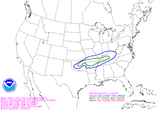
After several days of model flip-flops, models are now beginning to come into agreement that a significant winter storm is on the way Monday night into Tuesday. Their are still several questions remaining including amounts, the exact track of the low, and where the heaviest precipitation will set-up. This one may FINALLY be the first significant winter storm after several storms missing us to the north this year. Their will be at least 2 pieces of energy that have increased potential to dump significant amounts of wintry precipitation. The first will be Monday night through Tuesday night. Right now precipitation looks to be mainly snow over Southern Indiana with a mix of sleet/freezing rain/snow across Northern/Western Kentucky. The potential for several inches of snow is possible over Southern Indiana with a little less over Northern/Western Kentucky due to sleet and freezing rain mixing in. Snow/ice amounts still are nearly impossible to pinpoint at this time. However, several inches of snow and ice seem very probable across Kentuckiana. Their is still quite a bit of uncertainity to how far north the precipitation will make it. Right now it looks like anywhere south of I 70 is in for a decent winter weather event. However, if models continue to agree with a suppressed solution, the main precipitation may be even further south than expected. This storm will considerably impact travel conditons Monday night into Tuesday night.
Here is a preliminary map of where the ice and snow may set up. Again this is subject for change...

Here are what different National Weather Services are saying across the region...
NWS in Indianapolis: A DEVELOPING STORM SYSTEM EARLY NEXT WEEK HAS THE POTENTIAL TO PRODUCE WINTRY PRECIPITATION ACROSS THE AREA MONDAY NIGHT THROUGH THURSDAY.THERE REMAINS CONSIDERABLE UNCERTAINTY WITH THE SYSTEM AND ITS EVENTUAL TRACK...BUT RESIDENTS SHOULD CONTINUE TO MONITOR FUTURE FORECASTS AND OUTLOOKS OVER THE NEXT SEVERAL DAYS.
NWS in Louisville: THE POTENTIAL FOR SIGNIFICANT WINTRY PRECIPITATION EXISTS DURING THIS TIME PERIOD AS A WAVE OF ENERGY RIDES THE FAST ZONE FLOW INTO THE OHIO VALLY. HOWEVER...MODELS REMAIN IN DISCORD OVER TIMING AND THERMAL PROFILES. 12Z GFS IS VERY PROGRESSIVE WITH THE WAVE WITH A COLDER THERMAL PROFILE WHILE THE 12Z ECMWF IS SLOWER WITH THE WAVE AND A WARMER THERMAL PROFILE. LATEST ENSEMBLES OFFER A MORE MIDDLE OF THE ROAD SOLUTION SO WILL SIDE TOWARD THEM. FOR THIS FORECAST PACKAGE WILL CONTINUE 50 TO 60 POPS FOR MON NIGHT THROUGH WED WITH MOSTLY SNOW OVER THE NORTHERN FORECAST AREA (FA) AND A MIX OF SNOW/SLEET/FREEZING RAIN OVER THE SOUTH. THE POTENTIAL EXISTS FOR SIGNIFICANT AMOUNTS OF THIS WINTRY PRECIPITATION. 12Z GFS INDICATES NEGATIVE EPV OVER AN AXIS OF GOOD FRONTOGENESIS ACCORDING TO SPATIAL HEIGHT CROSS SECTIONS...SO THERE ARE GOOD DYNAMICS IN PLACE FOR SIGNIFICANT PRECIP AMOUNTS. HOWEVER...IT/S HARD TO PIN DOWN AMOUNTS AT THIS POINT IN TIME. PLEASE STAY TUNED FOR FORECAST UPDATES WITH THIS SYSTEM.
NWS in Paducah: LOW CONFIDENCE CONTINUES IN THE EXTENDED (MONDAY NIGHT THROUGH FRIDAY). WILL NOT ELABORATE ON SPECIFIC RUN-TO-RUN AND MODEL-TO-MODEL DIFFERENCES BECAUSE THERE ARE TOO MANY TO DETAIL. HOWEVER...IN THE OVERALL SCHEME OF THINGS...THE POTENTIAL FOR SIGNIFICANT MIXED WINTRY PRECIPITATION APPEARS TO BE INCREASING FOR NEXT WEEK. EVEN THOUGH TIMING AND AMOUNTS ARE NEARLY IMPOSSIBLE TO DETERMINE AT THIS POINT...MODEL CONSENSUS SEEMS TO BE HINTING AT TWO ROUNDS OF PRECIPITATION. THE FIRST IS EXPECTED TO BEGIN LATE MONDAY AND PERSIST INTO LATE TUESDAY. THE OTHER LOOKS TO OCCUR LATE WEDNESDAY INTO THURSDAY. DURING THE FIRST EVENT...WARM AIR OVERRUNNING SUB-FREEZING AIR AT THE SURFACE SHOULD LEAD TO A MIX OF SLEET AND FREEZING RAIN...WITH SNOW POSSIBLY MIXED IN THE NORTH AND RAIN IN THE SOUTH.
Next storm looks to be Wednesday night into Thursday night. At this time it looks this one could also end up being a winter weather maker, however latest models have suggested that rain will be the dominate precipitation type. Still several days to watch this one so...STAY TUNED!
Thursday, January 22, 2009
Thursday/Late Afternoon
WEATHER CODE: GREEN ***No hazardous weather expected overnight***

Monday/Tuesday system
It has been a day of watching the latest computer models and by no means are we even close to a solution for early next week. As mentioned in earlier posts, the precipitation threat for Monday night/Tuesday is beginning to increase. The problem that we will be trying to sort out the next couple of days is precipitation type. If we go by the majority of computer models today, snow lovers would be disappointed. The EURO has gone toward a Great Lakes Cutter solution while the GFS has the storm further south and a bit more QPF than yesterday. As you can see, computer models continue to flip-flop back and forth so were almost at the same place we were yesterday at this time. Looking at the meteorology, it would almost be impossible for a GLC due to the high pressure system in the North Central United States. I'm still going to stick with all snow for this system and their is still a decent shot at several inches. We will be closer to a solution tomorrow and models should diverge on a definite solution Saturday/Sunday. Below is what different National Weather Services are saying about this first storm system...
NWS in Louisville: THE NET RESULT IS THAT PRECIPITATION STILL LOOKS LIKE A GOOD BET LATE MONDAY NIGHT AND THROUGHOUT THE DAY ON TUESDAY. PRECIPITATION TYPE IS STILL JUST TOO EARLY TO TELL. THE 12Z ENSEMBLE PLUME DATA SHOWS BETTER TEMPORAL TIMING OF PRECIPITATION IN THE AREA...BUT PRECIPITATION TYPE FROM ALL THE MODELS IS ALL OVER THE PLACE. FOR NOW HAVE OPTED TO KEEP MOSTLY SNOW OVER SOUTHERN INDIANA AND THE NORTHERN HALF OF KY WITH A MIX OF SNOW/SLEET ACROSS SOUTHERN KY. IF THE TEMPS TRENDS CONTINUE TO INCREASE...WE COULD SEE MORE OF RAIN ACROSS THE SOUTH WITH A WINTRY MIX ACROSS THE NORTH. PERSONS WITH TRAVEL PLANS EARLY NEXT WEEK SHOULD STAY TUNED THROUGHOUT THE WEEKEND FOR THE LATEST UPDATES.
To see the full forecast discussion for NWS in Louisville click HERE
NWS in Indianapolis: MORE SIGNIFICANT ENERGY EJECTION AND RESULTANT WINTRY WEATHER SYSTEM NEXT WEEK STILL HIGHLY UNCERTAIN GIVEN CONTINUED WIDE VARIATION IN MODELS AND THEIR OWN RUN TO RUN CHANGES. MERGING OF NRN AND SRN STREAM FLOWS REMAINS QUESTION AND THIS IMPACTS HOW SYSTEM WILL EJECT INTO OUR PART OF THE COUNRTY. LEANING TOWARDS EURO SOLUTION WHICH NOW SHOWS ITS OWN HINTS OF SOLUTION COMPARABLE TO GFS. GIVEN DIFFERENCES...CURRENT PCPN FCST STILL SEEMS TO BE PRETTY GOOD BUT PCPN TYPE AND AMOUNT STILL UNCERTAIN. PHASING OF FLOWS AND EJECTING WAVE OUR WAY FAVORS PRETTY DECENT SYSTEM THAT MAY BRING VERY MILD AIR VERY CLOSE...IF NOT INTO INDIANA. AND THUS POTENTIAL FOR DECENT RAIN...AND/OR DECENT SNOW HERE OR NEAR HERE. SO FORECAST TO REMAIN AS CHANCE POPS AND MAINLY SNOW AS ALL MODELS SUGGEST ARCTIC SURFACE HIGH COULD BE A PREDOMINATING FEATURE AS SHORT WAVES AND ASSOCIATED SURFACE SYSTEM IMPINGES ON ITS SOUTH EDGE.
NWS in Paducah: LOW CONFIDENCE IN THE EXTENDED FORECAST (NEXT WEEK). CONSENSUS LEANS TOWARD THE ECMWF...WHICH BRINGS GOOD CHANCES OF PRECIP INTO OUR REGION MONDAY NIGHT THROUGH TUESDAY NIGHT. LATEST GFS RUN INDICATES PRECIP CHANCES TUESDAY INTO TUESDAY NIGHT. THOUGH BOTH MODELS HAVE SOME PRECIP IN THE SAME GENERAL TIME FRAME...12Z ECMWF IS NOW RUNNING MUCH WARMER THAN GFS...WHICH IS VERY DIFFERENT FROM THE 00Z ECMWF RUN. THIS LEADS TO DIFFICULTY IN DECIDING PRECIP TYPE. AFTER LOOKING AT FORECAST SOUNDINGS...OVERALL LEANED TOWARD A WINTRY MIX FOR NOW...WHICH WILL NEED FINE TUNING AS THE NEXT FEW MODEL RUNS COME IN.
NWS in St. Louis: IT APPEARS THAT SURFACE LOW PRESSURE WILL FORM ALONG THE STRONGBAROCLINIC BOUNDARY THAT WILL BE LOCATED SOUTH OF THE CWA EARLY NEXT WEEK. THE POTENTIAL FOR A MAJOR WINTER EVENT IS INCREASING AS 12Z ECWMF AND GFS FOCUSED THE TRACK OF THE SYSTEM FURTHER SOUTH AND MAINTAINED BELOW FREEZING TEMPERATURES AT THE SURFACE ACROSS A GOOD PORTION OF THE CWA. MANY QUESTIONS STILL EXIST AND MODEL CONTINUITY IS VERY POOR ON HOW FAST THE MEAN TROF WILL KICK EAST...BUT THIS PATTERN CERTAINLY BARES WATCHING. SIGNIFICANT SNOW...SLEET AND/OR ICE ACCUMULATION MAY BE POSSIBLE ACROSS THE REGION IF THIS LATEST ROUND OF MODEL GUIDANCE IS CORRECT. WITH ANY LUCK THE MEDIUM RANGE MODEL SUITE WILL COME INTO BETTER AGREEMENT IN THE NEXT FEW DAYS AND SOME OF THE SENSIBLE WEATHER DETAILS WILL BECOME MORE CLEAR. FOR NOW HAVE INCREASED POPS FOR MONDAY NIGHT AND TUESDAY TO HIGH CHANCE.
Wednesday-Friday system
I'm not even going to try and say to much about this storm as the first storm still has a lot of question marks. However, it looks to be rain changing to snow, but again this is still several days away. Their is NO uncertainty that next week will be very active across the Ohio Valley Region! STAY TUNED!
Thursday/Early Afternoon
Latest 12Z GFS run is in...
Here is what I have discovered after this set of model runs...
-High pressure still trying to shove precipitation southward for Monday/Monday night. However, the threat for a more significant ice/snow event may be increasing once again.
-Storm Tuesday/Wednesday continues to look like the major storm. Right now looks like rain changing to heavy snow. The GFS puts down several inches of snow on the backside of the low.
The operational GFS and the EURO have also began to catch onto this idea. Unusual ensemble agreement with the storm being several days out...
More later...
Thursday/Late Morning
I cannot describe how exciting it is to track weather. One day we can be looking at a potential monster and the next day the storm is nearly gone. It's amazing how weather works and it's why I want to be in the business in the next few years.
Anyhow here is the latest for next week...
The progression of the storms next week has slowed down quite a bit. (According to computer models) What this means is the main storm system will probably not arrive until Tuesday and Wednesday. Some very light precipitation is possible Monday and Monday night, but this energy will likely be suppressed to the south due to a very strong high pressure system just to our north. Precipitation type will be the main issue. As the high moves east, it will allow for more southerly winds to return to the region. This would allow temperatures to rise around freezing or just above for Tuesday and Wednesday. All in all it looks to be a very close call. We could still see anywhere from rain to snow to ice or all of the above. This storm will likely not be ironed out until the weekend. (And maybe longer) More later...
Wednesday, January 21, 2009
Wednesday/Late Afternoon
WEATHER CODE: GREEN ***No hazardous weather expected***

Here is what a few National Weather Services are saying about early next week...
NWS in Indianapolis: EXTENDED...GREAT DEAL OF UNCERTAINTY IN THE PATRN. IT APPEARS FROM THE GFS AND ECMWF THAT A SYSTEM WILL IMPACT INDIANA AT SOME POINT...BUT WHETHER THAT IS EARLY IN THE WEEK OR LATE IN THE WEEK OR SOMEWHERE IN THE MIDDLE AND HOW MUCH OF AN IMPACT IT HAS HERE AND WHETHER IT IS RAIN OR SNOW OR SOMETHING ELSE DEPENDS ON WHICH MODEL OR ENSEMBLE AVERAGE YOU LOOK AT. WITH ALL THIS UNCERTAINTY AGREE WITH HPC ON MAINTAINING CONSISTENCY WITH PREVIOUS FCST AND WILL STICK CLOSE TO HPC NUMBERS. THIS YIELDS SMALL CHCS FOR SNOW FROM SUNDAY NT ON. FOR TEMPS HAVE CUT SOME FROM HPC NUMBERS DAYS 6 AND 7. NOT READY TO COMMIT TO WARMUP EARLY IN THE WEEK THAT/S ONLY SHOWING UP IN LATEST RUNS OF A COUPLE MODELS.
NWS in Louisville: STRONG WAVE OUT IN THE SOUTHWEST U.S. WILL LIKELY END UP SENDING A SERIES OF UPPER LEVEL DISTURBANCES EASTWARD WITHIN THE MEAN FLOW. THE COMBINATION OF THE SW WAVE AND THE STRONGLY CONFLUENT FLOW ALOFT OVER THE GREAT LAKES LOOKS TO KEEP THESOUTHEAST RIDGE IN CHECK AND ALLOW THE SHALLOW PRE-EXISTING AIRMASS IN PLACE THROUGH MUCH OF THE PD. FROM A PATTERN RECOGNITION STANDPOINT...THE INGREDIENTS SEEM TO BE COMING TOGETHER FOR A DECENT OVERRUNNING PRECIPITATION EVENT. OVERALL FORECASTER CONFIDENCE IS HIGH ON THIS KIND OF EVENT HAPPENING. HOWEVER...THERE IS STILL UNCERTAINTY IN REGARDS TO HOW STRONG THE WARM AIR ADVECTION WILL BE AND WHAT EFFECT IT WILL HAVE ON PRECIPITATION TYPE. OVERALL TRENDIN THE OPERATIONAL MODELS HAS BEEN SLIGHTLY COLDER WITH TEMPS. ON THE OTHER HAND...THE GFS ENSEMBLES ARE SLIGHTLY WARMER AND RESULT IN MORE OF A MIXED PRECIPITATION EVENT. GFS ENSEMBLE PLUME CHARTS CONTINUE TO SHOW A LARGE SPREAD IN PRECIPITATION ARRIVAL. SO WE HAVE BACKED OFF POPS SLIGHTLY FOR MONDAY AND TRENDED THINGS SLIGHTLY SLOWER WITH MORE EMPHASIS ON MONDAY NIGHT AND TUESDAY FOR PRECIPITATION. PRECIPITATION LOOKS TO DIMINISH A BIT AND POSSIBLY END BY WEDNESDAY. FOR TEMPS...HAVE TRENDED THINGS CLOSE TO THE 12Z OP GFS AND THE 12Z ENSEMBLE MEAN. THIS RESULTS IN A SLIGHTLY COOLER TEMP FCST...BUT CARRIES GOOD CONTINUITY FROM THE PREVIOUS TWO FCSTS.
NWS in Paducah: OVERALL FLOW PATTERN IS EXPECTED TO CHANGE NEXT WEEK WITH ENERGY DIVING SOUTH INTO THE SOUTHWEST WHILE WE HAVE ZONAL OR NEAR ZONAL FLOW. THIS IS GIVING THE MODELS FITS AND THEY ARE HAVING TROUBLE DETERMINING WHERE THE INDIVIDUAL WAVES WILL BE LOCATED. WITH THIS PACKAGE BLENDED HPC...GFS...AND GFS ENSEMBLES. CONFIDENCE LEVEL NOT TOO HIGH WITH THIS TYPE OF FLOW REGIME. ENSEMBLES SEEMED TO TOUCH ON PRECIPITATION ON TUESDAY AS THE BEST CHANCE OF ANY TIME PERIOD. OTHERWISE CHANCES OF ANY SIGNIFICANT PRECIPITATION IS LOW. AS USUAL...FREEZING LINE WILL LIKELY SPLIT MOST OF THE CWA UNTIL TUESDAY NIGHT OR WEDNESDAY WHEN IT SHOULD BE ALL SNOW.
Even several National Weather Services continue to disagree with one another. NWS in Louisville hints at a decent event. National Weather Service in Paducah says "Otherwise chances of any significant precipitation is low". And the National Weather Service in Indianapolis pretty much says nothing. Their is a chance the "Main event" could be late next week instead of early next week and that would most likely be a rain event. That's not to say their wouldn't be snow Monday and Tuesday, but it would be of light variety. Their are a range of possibilities and this one will be very fun to track...stay tuned!
Wednesday/Early Afternoon
I may have jumped the gun a little yesterday with next week's system. I'm still gaining knowledge as to the accuracy of computer models 5-7 days out. If they show a storm, I tend to get excited and blow it out of porportion. We can all become better weather forecasters and I am learning as I go along.
Anyhow the GFS lost the storm last night and now it has brought it back. Yesterday afternoon it had a huge storm with a massive overunning event which would lead to a significant snow/ice event. The storm is back, but not as strong as yesterday afternoon. (Again this is the GFS) If the 12Z GFS was to pan out, that would put down a couple of inches for most of the region. The latest GFS keeps the main piece of energy well to our west, off the coast of California, and then rides it up into the Great Lakes by Monday night. This would quickly change any snow to rain. Again these models are pish posh at this point and due to the inconsistency a solution is far from being made. I will back off on my wording yesterday, but this one definetly bears watching! I will have more later this afternoon...
Anyhow the GFS lost the storm last night and now it has brought it back. Yesterday afternoon it had a huge storm with a massive overunning event which would lead to a significant snow/ice event. The storm is back, but not as strong as yesterday afternoon. (Again this is the GFS) If the 12Z GFS was to pan out, that would put down a couple of inches for most of the region. The latest GFS keeps the main piece of energy well to our west, off the coast of California, and then rides it up into the Great Lakes by Monday night. This would quickly change any snow to rain. Again these models are pish posh at this point and due to the inconsistency a solution is far from being made. I will back off on my wording yesterday, but this one definetly bears watching! I will have more later this afternoon...
Tuesday, January 20, 2009
Tuesday/Late Evening
WEATHER CODE: GREEN ***No hazardous weather expected***

Focus will be on next week's storm system...
Just wanted to briefly discuss the weather for the rest of the week and then talk about the potential for a nasty winter storm next week...
After temperatures last week in the single digits and teens for highs, temperatures will rebound into the middle 30's tomorrow and lower 40's by Thursday. A cold front will slide through the region Friday morning and this will cool temperatures back into the upper 20's for the weekend and the colder weather will likely last through the rest of next week. Precipitation the rest of the week will be very minimal with only a chance for a few flurries and or snow showers Friday as the front enters the region.
NASTY WINTER STORM POSSIBLE NEXT WEEK
We have been discussing this for the last few days now, and it's becoming apparent that a winter storm is on it's way for at least a portion of the Midwestern Region early next week. Computer models today have been consistent in bringing a storm into the Midwest, but they have struggled with the potential track of the storm(s). Computer models, particularly the GFS has several waves of low pressure riding up along a front Monday through Wednesday. The track of these waves will determine the amount of precipitation and the precipitation type. Their are several computer models that are now depicting a massive overunning event for Kentuckiana. A couple of the more accurate weather models we use to forecast weather (GFS, EURO) look like a nightmare for the Ohio Valley Region. Both of these models support a massive overunning event with two storm systems riding to our south, placing us in the area for frozen precipitation. The question is, will that be ice or snow? And at this point I can't answer that, but what I can do is speculate. Due to the high pressure system that will be in place across the Northern sections of the United States, this storm will likely be supressed southward. If you want a massive ice or snowstorm, you don't want the storm to far south, as the main moisture field would be shoved southward into Tennessee. Right now I would take the track from south of St. Louis to Southern Kentucky. This would place us in a potentially dangerous situation beginning Monday and ending Tuesday night or Wednesday. I hate to jump the gun here, and I may regret it, but to me it seems very probable that the first winter storm has it's eyes fixed on us early next week. It's to early to talk about where the ice/snow line sets up. However, a major ice/snow event looks likely heading into early next week.
To take a look at what different National Weather Services are saying about the storm...click the links below...
NWS in Lousville: click HERE
NWS in Paducah: click HERE
NWS in St. Louis: click HERE
Tuesday/Mid Afternoon
This is NOT the whole updated forecast package. That will be later tonight...
Just wanted to give you a quick update on the potential for a storm early next week. There has been lots of talk of this one being the "Big One" for the Ohio Valley. However, we are still several days away from the actual event and models are going to do their usual flip flop with track/intensity/precipitation types. What I will say is MANY computer models have a storm and that is what has got me excited.
Here are just three solutions the storm may take early next week...
-Great Lakes Cutter...Mainly rain here with snow well to our north.
-Ohio Valley Storm: Low tracks across Southern Kentucky then into Eastern Kentucky. This would bring several inches of snow across our area.
-Supressed Storm: The Storm is supressed to the south with the main moisture field across the Southern states. Some snow, but not very much in terms of accumulation.
As you can see their are still several options and probably more than just 3. I will have a more in depth update later this evening. The evening post will be out around 10 o'clock! STAY TUNED!
Monday, January 19, 2009
Monday/Late Afternoon
WEATHER CODE: YELLOW ***Slick roads may develop tonight with light snow and potential refreeze***

After several days of no posting...its back to weather. Most areas got a good inch of snow yesterday with some 2 inch amounts across the Bluegrass region. Their was lighter totals to the north across South Central and Central Indiana.
Tonight a pretty weak system will travel across the region. This doesn't have to much moisture to work with, but with temperatures bottoming out in the teens...snow ratios will be rather high. Right now I will say up to one half of an inch will be possible across Western Kentucky, eastward into Northern and Central Kentucky. Areas across Central/South Central Indiana will see a dusting at best.
NWS in Louisville: TEMPERATURES ARE FORECAST TO DROP INTO THE LOW TO MID TEENS...SO SNOW RATIOS WOULD BE RATHER HIGH OVERNIGHT...SUCH THAT A QUARTER TO A THIRD OF AN INCH IS POSSIBLE IN AREAS WEST OF I-65.
Another weather problem overnight will be a potential refreeze. Many areas south of a Seymour, North Vernon, to Bedford line recieved anywhere between .50 to 2 inches of snow last night. Due to plentiful sunshine today and temperatures close to freezing...most of this snow has melted. Any water left overnight will quickly freeze with temperatures dropping into the teens. Main roads should be OK, but secondary roads will become slick and hazardous overnight. Please be careful traveling later tonight into tomorrow morning!
Temperatures will warm into the middle 30's Wednesday and lower 40's Thursday. Next system arrives Friday into Saturday, but at this point models supress this storm well to the south. I opted to leave forecast dry, but I will throw in a slight chance for rain and or snow Friday night into Saturday.
There has been some talk about a potential storm for early next week. Computer models are all over the place. Anyhow, just like any storm...I will be watching this one! STAY TUNED!
I AM BACK!
After no posting for several weeks...I AM BACK!
The reason for me not posting was because my blog was down. I contacted the administration about the problem and now the problem has been fixed. I will have the latest weather information later this afternoon...
The reason for me not posting was because my blog was down. I contacted the administration about the problem and now the problem has been fixed. I will have the latest weather information later this afternoon...
Friday, January 2, 2009
Friday/Early Morning
WEATHER CODE: GREEN ***No hazardous weather expected***

I am back from my awesome trip in Alabama! We went to a awesome youth conference down their...God moved in ways I cannot even explain!
So what is the Lord preparing for us weatherwise!
Short post for now then longer post later...
Next system is about to move into the area and it will make for a wet weekend, and much cooler weather by early next week.
I haven't been able to check much into the computer models, but have looked at enough to know that a potential snow maker is on the way Monday night through Wednesday of next week. This one should be interesting to track. Much more later...
Subscribe to:
Posts (Atom)
.jpg)