
Saturday, May 30, 2009
Saturday/Early Evening 4
Storms are beginning to initiate in Central Illinois and are probably becoming severe as I type this. These will arrive somewhere between 8 and 10 PM.

Saturday/Early Evening 3
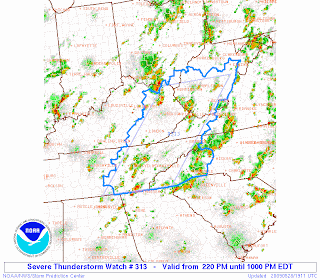
New SEVERE THUNDERSTORM WATCH has been issued for the entire viewing area.

SPC SAYS: DISCUSSION...THUNDERSTORMS EXPECTED TO INCREASE IN NUMBER AND INTENSITY ACROSS THE WATCH AREA AS AIR MASS CONTINUES TO DESTABILIZE UNDER STRONG HEATING. WITH 35-45KT OF SHEAR AND MLCAPES AOA 2000 J/KG...SEVERE THUNDERSTORMS INCLUDING POSSIBLE SUPERCELLS ARE LIKELY. PRIMARY THREAT WILL BE LARGE HAIL AND DAMAGING WINDS PARTICULARLY WITH ANY SUPERCELL AND LINE SEGMENTS THAT DEVELOP.

SPC SAYS: DISCUSSION...THUNDERSTORMS EXPECTED TO INCREASE IN NUMBER AND INTENSITY ACROSS THE WATCH AREA AS AIR MASS CONTINUES TO DESTABILIZE UNDER STRONG HEATING. WITH 35-45KT OF SHEAR AND MLCAPES AOA 2000 J/KG...SEVERE THUNDERSTORMS INCLUDING POSSIBLE SUPERCELLS ARE LIKELY. PRIMARY THREAT WILL BE LARGE HAIL AND DAMAGING WINDS PARTICULARLY WITH ANY SUPERCELL AND LINE SEGMENTS THAT DEVELOP.
Saturday/Early Evening 2
There's also another Mesoscale discussion for Central Illinois. If a watch is issued, it may include Western and potentially Southern Indiana.

SPC says: BECOMING INCREASINGLY CONCERNED ABOUT CU FIELD EXPANSION ALONG ADVANCING COLD FRONT AS IT PROGRESSES SEWD INTO IL. ALTHOUGH FLOW HAS VEERED CONSIDERABLY IN THE WAKE OF EARLIER SHORTWAVE TROUGH...IT APPEARS SUFFICIENT LOW LEVEL CONVERGENCE WILL BE AVAILABLE...GIVEN VERY STEEP LAPSE RATE ENVIRONMENT...FOR THUNDERSTORM INITIATION WITHIN THE NEXT FEW HOURS. LATEST DIAGNOSTIC DATA ALSO SUGGESTS PW VALUES ARE HOLDING ABOVE ONE INCH ACROSS THE SRN HALF OF IL WHICH DESPITE VEERING/DRYING BOUNDARY LAYER SHOULD SUPPORT ROBUST CONVECTIVE DEVELOPMENT CAPABLE OF GENERATING LARGE HAIL/DAMAGING WINDS. WW MAY BE REQUIRED ALONG NW-SE ORIENTED FASHION TO ACCOUNT FOR THIS INCREASED SEVERE RISK.

SPC says: BECOMING INCREASINGLY CONCERNED ABOUT CU FIELD EXPANSION ALONG ADVANCING COLD FRONT AS IT PROGRESSES SEWD INTO IL. ALTHOUGH FLOW HAS VEERED CONSIDERABLY IN THE WAKE OF EARLIER SHORTWAVE TROUGH...IT APPEARS SUFFICIENT LOW LEVEL CONVERGENCE WILL BE AVAILABLE...GIVEN VERY STEEP LAPSE RATE ENVIRONMENT...FOR THUNDERSTORM INITIATION WITHIN THE NEXT FEW HOURS. LATEST DIAGNOSTIC DATA ALSO SUGGESTS PW VALUES ARE HOLDING ABOVE ONE INCH ACROSS THE SRN HALF OF IL WHICH DESPITE VEERING/DRYING BOUNDARY LAYER SHOULD SUPPORT ROBUST CONVECTIVE DEVELOPMENT CAPABLE OF GENERATING LARGE HAIL/DAMAGING WINDS. WW MAY BE REQUIRED ALONG NW-SE ORIENTED FASHION TO ACCOUNT FOR THIS INCREASED SEVERE RISK.
Saturday/Early Evening
Mesoscale Discussion has been issued for parts of the area. This includes those that live anywhere east and southeast of Louisville.

SPC SAYS: TRENDS ARE BEING MONITORED FOR THE POSSIBILITY OF AN INCREASING SEVERE THREAT WHICH COULD REQUIRE A WW LATE THIS AFTERNOON. BOUNDARY LAYER HEATING BENEATH A FAIRLY COLD MID-LEVEL ENVIRONMENT ...AND 40-50 KT WEST NORTHWESTERLY 500 MB FLOW ON THE SOUTHERN PERIPHERY OF THE GREAT LAKES UPPER TROUGH...IS CONTRIBUTING TO MODERATELY STRONG DESTABILIZATION ACROSS THE REGION. LATEST RUC ANALYSIS SUGGESTS MIXED LAYER CAPE IS NOW IN EXCESS OF 1500 J/KG...WITH FURTHER DESTABILIZATION POSSIBLE. MID-LEVEL INHIBITION IS BECOMING INCREASINGLY NEGLIGIBLE...AND INITIATION OF STORMS MAY ALREADY BE UNDERWAY NEAR/EAST OF LOUISVILLE. FORCING ASSOCIATED WITH A WEAK SHORT WAVE IMPULSE SEEMS LIKELY TO SUPPORT INCREASING/INTENSIFYING CONVECTIVE DEVELOPMENT ACROSS EAST CENTRAL KENTUCKY WITHIN THE NEXT COUPLE OF HOURS. IN THE PRESENCE OF STRONG DEEP LAYER SHEAR...A COUPLE OF SUPERCELLS APPEAR POSSIBLE BEFORE UPSCALE GROWTH INTO A SMALL ORGANIZED MESOSCALE CONVECTIVE SYSTEM OCCURS ACROSS EAST CENTRAL/SOUTHEAST KENTUCKY THROUGH THE 23-00Z TIME FRAME. AN ISOLATED BRIEF TORNADO IS NOT OUT OF THE QUESTION...BUT LARGE HAIL SEEMS TO BE THE PRIMARY INITIAL THREAT BEFORE THE RISK FOR DAMAGING WINDS INCREASES LATER THIS AFTERNOON.

SPC SAYS: TRENDS ARE BEING MONITORED FOR THE POSSIBILITY OF AN INCREASING SEVERE THREAT WHICH COULD REQUIRE A WW LATE THIS AFTERNOON. BOUNDARY LAYER HEATING BENEATH A FAIRLY COLD MID-LEVEL ENVIRONMENT ...AND 40-50 KT WEST NORTHWESTERLY 500 MB FLOW ON THE SOUTHERN PERIPHERY OF THE GREAT LAKES UPPER TROUGH...IS CONTRIBUTING TO MODERATELY STRONG DESTABILIZATION ACROSS THE REGION. LATEST RUC ANALYSIS SUGGESTS MIXED LAYER CAPE IS NOW IN EXCESS OF 1500 J/KG...WITH FURTHER DESTABILIZATION POSSIBLE. MID-LEVEL INHIBITION IS BECOMING INCREASINGLY NEGLIGIBLE...AND INITIATION OF STORMS MAY ALREADY BE UNDERWAY NEAR/EAST OF LOUISVILLE. FORCING ASSOCIATED WITH A WEAK SHORT WAVE IMPULSE SEEMS LIKELY TO SUPPORT INCREASING/INTENSIFYING CONVECTIVE DEVELOPMENT ACROSS EAST CENTRAL KENTUCKY WITHIN THE NEXT COUPLE OF HOURS. IN THE PRESENCE OF STRONG DEEP LAYER SHEAR...A COUPLE OF SUPERCELLS APPEAR POSSIBLE BEFORE UPSCALE GROWTH INTO A SMALL ORGANIZED MESOSCALE CONVECTIVE SYSTEM OCCURS ACROSS EAST CENTRAL/SOUTHEAST KENTUCKY THROUGH THE 23-00Z TIME FRAME. AN ISOLATED BRIEF TORNADO IS NOT OUT OF THE QUESTION...BUT LARGE HAIL SEEMS TO BE THE PRIMARY INITIAL THREAT BEFORE THE RISK FOR DAMAGING WINDS INCREASES LATER THIS AFTERNOON.
Saturday/Mid Afternoon
Storms are beginning to pop. A few storms already up to 50 DBZ near Bedford and Petersburg. I am expecting these storms to strengthen and increase in coverage. We will probably see some kind of WATCH in the next 1 to 2 hours...
More soon...
More soon...
Saturday/Early Afternoon
Still waiting for storms to pop. Should be within the next hour or so. No MSD's (Mesoscale Discussions) have been issued for the area yet, but I would expect that to change within the hour. Couple of reasons why storms may not be popping quite yet is the clouds and rain showers over Southern Illinois. That batch of weak convection has sticked around longer than what I expected.
More later...
More later...
Saturday/Late Morning
Lifted indices are already around -3. Dew points are in the lower 60's region wide, and on the rise. Already, the atmosphere is beginning to destabilize, and storms should pop between 12-2 o'clock. Any watch that is issued will probably be a tornado watch due to the potential for isolated tornadoes...
Saturday/Early Morning
New SPC numbers are in, and they're nearly a copycat of the last update.
My current thinking is thunderstorms (some severe) will develop in South Central Illinois early this afternoon. The air mass across Kentuckiana today will be rather unstable, so storms will strengthen as they move east/southeast toward the region. The best potential for an isolated tornado or two will run from Seymour to Louisville. This is where the strongest mid level shear will be present. The main threat, however, will be damaging winds and large hail. Some of the hail may be as big as golfballs, and we could easily see damaging wind gusts as storms become linear, and begin to bow out. I will continue to keep you updated on here and on TWITTER throughout the afternoon, and evening. Stay tuned!
My current thinking is thunderstorms (some severe) will develop in South Central Illinois early this afternoon. The air mass across Kentuckiana today will be rather unstable, so storms will strengthen as they move east/southeast toward the region. The best potential for an isolated tornado or two will run from Seymour to Louisville. This is where the strongest mid level shear will be present. The main threat, however, will be damaging winds and large hail. Some of the hail may be as big as golfballs, and we could easily see damaging wind gusts as storms become linear, and begin to bow out. I will continue to keep you updated on here and on TWITTER throughout the afternoon, and evening. Stay tuned!
Saturday/Very Early Morning
Don't know if anyone is up, but the latest numbers are in from the Storm Prediction Center for today's potential severe weather event. We are in the 15% risk area for wind and hail, and a 5% risk area for tornadoes. (Maps and discussion below)


SEVERE WEATHER OUTLOOK-Today

TORNADO PROBABILITY-Today

DAMAGING WIND PROBABILITY

SEVERE HAIL PROBABILITY

SEVERE HAIL PROBABILITY

SPC SAYS: AIR MASS DOWNSTREAM ALONG/S OF THE STALLED FRONT FROM SRN IL/IND/OH INTO KY AND FAR N TN WILL BECOME MODESTLY UNSTABLE OWING TO UPR 50S SFC DEW POINTS AND HEATING. AS STRONGER PVA ARRIVES BY EARLY AFTN...STRONGER STORMS ARE EXPECTED TO FORM ALONG SRN/SERN FRINGES OF MORNING CONVECTION. ALTHOUGH PRIMARY MODE SHOULD REMAIN MULTICELLULAR WITH SPORADIC LINEAR EVOLUTION...OCCASIONAL SUPERCELL STRUCTURES CANNOT BE RULED OUT. THIS WILL ESPECIALLY BE TRUE IN A ZONE N/NE OF THE SFC LOW TRACK IN SRN IND/NRN-CNTRL KY WHERE MORE SUBSTANTIAL DIRECTIONAL SHEAR BETWEEN SFC-H5 WILL EXIST. RISKS FOR LARGE HAIL...DMGG WIND GUSTS AND BRIEF TORNADOES CAN BE EXPECTED. ACTIVITY WILL QUICKLY TRANSLATE INTO THE HIGHER TERRAIN OF WV/KY/TN DURING THE EVENING AND WEAKEN.
I will be updating on here, and on TWITTER all day today as storms develop. I will answer any questions you have about the severe weather event tomorrow. Email me at pateo90@hotmail.com or drop me a comment on here.
Friday, May 29, 2009
Friday/Mid Afternoon
WEATHER CODE: GREEN ***No hazardous weather expected today***


Focus will be on the potential for severe weather tomorrow...
The Storm Prediction Center has placed the entire region in a SLIGHT RISK for severe weather tomorrow.
SEVERE WEATHER OUTLOOK-Saturday

SEVERE WEATHER PROBABILITY-Saturday

MY DISCUSSION: A pretty good set-up for severe weather is evident tomorrow. Only thing lacking will be potential debris (clouds/rain) and the timing, which for now is expected to be in the late morning and early afternoon hours. Storms will set-up shop by mid morning across Central Illinois and Southwest Indiana. As the morning wears on and we head into the early afternoon hours the atmosphere will begin to become more unstable across Southern Indiana and Kentucky. Main question is obviously the storm mode. The Storm Prediction Center says it could either be line segments or individual supercells with large hail and a few tornadoes. With the very strong jet stream, and vertical shear at about 40 to potentially 60 knots, I expect storms to take on more of a supercelluar nature. It wouldn't suprise me to see both storm modes tomorrow as severe weather variables favor both line segments and supercelluar storms. Storms will be capable of producing hail the size of golf balls, and a few isolated tornadoes are possible. Wind damage is also possible with storms that become more linear in nature. Right now this is NOT expected to be a widespread severe weather event, however if storms come in later than expected (late afternoon and early evening) a much more widespread severe weather event is possible.
SPC SAYS: AN UPPER-LEVEL TROUGH OVER THE CNTRL APPALACHIAN MTNS WILL REMAIN IN PLACE TONIGHT AND SATURDAY AS A 60 TO 75 KT MID-LEVEL JET MOVES SEWD INTO THE BASE OF THE TROUGH. AT THE SFC...A FRONTAL BOUNDARY SHOULD BE LOCATED FROM NRN MO ESEWD ACROSS SRN IL INTO CNTRL KY SATURDAY. GFS/NAM/NAMKF AND SREF MODEL FORECASTS ARE IN FAIRLY GOOD AGREEMENT LATE SATURDAY MORNING WITH A CLUSTER OF THUNDERSTORMS LOCATED ACROSS IL...SRN IND AND WRN KY IN THE RIGHT REAR QUADRANT OF THE MID-LEVEL JET. CONVECTION WITH THIS FEATURE OR NEW STORMS THAT DEVELOP SOUTH OF THE CLUSTER SHOULD MOVE SEWD ALONG THE BOUNDARY ACROSS CNTRL KY DURING THE AFTERNOON. A CONSENSUS OF FORECAST SOUNDINGS IN CNTRL KY AT 21Z SATURDAY SHOW MODERATE INSTABILITY WITH 40 TO 50 KT OF VERTICAL SHEAR SUGGESTING THE ENVIRONMENT WILL BE FAVORABLE FOR A SEVERE THREAT WITH THE CONVECTIVE CLUSTER. AT THIS TIME...CONVECTIVE MODE REMAINS QUESTIONABLE. IF ISOLATED SUPERCELLS CAN ORGANIZE...THEN LARGE HAIL AND A FEW TORNADOES WILL BE POSSIBLE. IF LINE-SEGMENTS ARE FAVORED...THEN THE PREDOMINANT THREAT COULD BE WIND DAMAGE. ANOTHER UNCERTAINTY IS THE TIMING OF THE CONVECTIVE SYSTEM. IF THE TIMING IS LATER IN THE AFTERNOON WHEN INSTABILITY IS MAXIMIZED...THEN THE SEVERE THREAT COULD BE MORE SUBSTANTIAL.
Thursday, May 28, 2009
Thursday/Early Evening
Scattered showers and thunderstorms continue, although they are not numerous. Their have been reports of small hail near Madison. Storms will begin to wane after dark. If severe storms were going to develop, they already would have, so I am not expecting any severe weather. However, stronger storms through this evening will have the potential to produce brief heavy rain and small hail.
More later tonight...
More later tonight...
Thursday/Late Afternoon
The new SPC (Storm Prediction Center) update is out. (New maps/discussion below) Not to much of a change, except we are now in a 2% risk area for tornadoes.


Storms are trying to get their act together just north of Evansville and near Vincennes, however they are having trouble doing so. Again, only an isolated severe storm is possible with more widespread severe weather to our east and south. Most storms that form tonight will be non-severe with brief heavy downpours, cloud to ground lightning, and small hail.
Less humid and drier weather on the way tomorrow. What can you expect for the rest of the weekend into early next week? I will have more later tonight...Have a God blessed afternoon and evening!
SEVERE WEATHER OUTLOOK

TORNADO PROBABILITY

Storms are trying to get their act together just north of Evansville and near Vincennes, however they are having trouble doing so. Again, only an isolated severe storm is possible with more widespread severe weather to our east and south. Most storms that form tonight will be non-severe with brief heavy downpours, cloud to ground lightning, and small hail.
Less humid and drier weather on the way tomorrow. What can you expect for the rest of the weekend into early next week? I will have more later tonight...Have a God blessed afternoon and evening!
Thursday/Mid Afternoon
Storms are now beginning to fire. The sun was able to come out for a few hours now, and that's all it's going to take for even more showers and thunderstorms to develop.
A good majority of the area is still in a SLIGHT RISK for severe weather. (Latest Map below) The next updated SPC maps/discussion is scheduled by 4:00 PM-UTC time.

The more widespread severe weather will be confined to Eastern Tennessee, and Southern/Eastern Kentucky, and in fact that area is under a SEVERE THUNDERSTORM WATCH (as depicted below).
We still have potential to see some isolated severe weather. Severe storms that do develop will have the potential to produce severe hail up to at least quarters and damaging winds in excess of 60 MPH. I am NOT expecting a widespread severe weather event, but any storm that can get it's act together will have the potential to produce some damage.
A good majority of the area is still in a SLIGHT RISK for severe weather. (Latest Map below) The next updated SPC maps/discussion is scheduled by 4:00 PM-UTC time.

The more widespread severe weather will be confined to Eastern Tennessee, and Southern/Eastern Kentucky, and in fact that area is under a SEVERE THUNDERSTORM WATCH (as depicted below).

We still have potential to see some isolated severe weather. Severe storms that do develop will have the potential to produce severe hail up to at least quarters and damaging winds in excess of 60 MPH. I am NOT expecting a widespread severe weather event, but any storm that can get it's act together will have the potential to produce some damage.
Thursday/Early Afternoon
Still waiting for storms to pop. Not much sun has been able to destabilize the atmosphere, so if sun does not come out, we may be looking at only a few isolated thunderstorms.
More later...
More later...
Thursday/Early Morning
WEATHER CODE: YELLOW ***More showers and thunderstorms this afternoon and evening***


More showers and thunderstorms are expected this afternoon and will continue through early evening. The cold front is still meandering to our west and still has yet to cross through the region, so this will be the energy to set off these storms. Along with support from the cold front, we will again have an unstable air mass. With all of this in mind, we still could see some isolated severe weather later today. Marginally severe hail and an isolated damaging wind gust will be possible with any of the stronger storms that develop.
And in fact the SPC has placed parts of our eastern forecast area in a SLIGHT RISK for severe weather for today. (CLICK ON ANY IMAGE FOR A LARGER VIEW)

The severe weather threat for later this week has shifted to our north, for now. The SPC still has Central Indiana, Northern Indiana, Northwestern Ohio, and Northern Illinois in the 30% risk area. (Map Below)

This risk area will probably be moved around a bit the next few days. Computer models are having trouble depicting the exact tracks of the MCS's, (Multi Convective System) so we will still have to keep our guard up as we go into the weekend.
Have a God blessed afternoon! More later...
Wednesday, May 27, 2009
Wednesday/Mid Afternoon 2
The Storm Prediction Center is now monitoring the area for a potential WATCH. If the watch is issued it would inlcude those from Indianapolis to Seymour to Evansville and Paducah...

SPC says: CONVECTION IS BEGINNING TO DEEPEN/INTENSIFY ACROSS PORTIONS OF THE MID MS VALLEY...ESPECIALLY FROM SERN MO INTO SRN IL. THIS ACTIVITY IS EVOLVING WITHIN A VERY BUOYANT AIRMASS CHARACTERIZED BY STEEP LOW LEVEL LAPSE RATES...ON THE ORDER OF 8 C/KM IN THE LOWEST 3KM...AND MLCAPE VALUES OF ROUGHLY 2500 J/KG. LATEST VIS IMAGERY AND LONGER RADAR LOOPS SUGGEST TWO REMNANT MCS VORT CENTERS ARE LOCATED JUST NW OF SGF AND NEAR LIT. WITH BOUNDARY LAYER EXPECTED TO FURTHER DESTABILIZE IT APPEARS A RATHER BROAD SWATH OF ENHANCED THUNDERSTORM ACTIVITY WILL EVOLVE FROM NERN AR...NEWD INTO PORTIONS OF SRN IL/IND...PARTLY DRIVEN BY AFOREMENTIONED UPPER VORT MAXIMA...BUT IN LARGE PART BY AFTERNOON HEATING. GIVEN THE WEAK SHEAR ENVIRONMENT IT APPEARS DOWNBURSTS OR PERHAPS SOME HAIL MAY ACCOMPANY THE STRONGEST ACTIVITY. WILL CONTINUE TO MONITOR THIS REGION FOR POSSIBLE WW.

SPC says: CONVECTION IS BEGINNING TO DEEPEN/INTENSIFY ACROSS PORTIONS OF THE MID MS VALLEY...ESPECIALLY FROM SERN MO INTO SRN IL. THIS ACTIVITY IS EVOLVING WITHIN A VERY BUOYANT AIRMASS CHARACTERIZED BY STEEP LOW LEVEL LAPSE RATES...ON THE ORDER OF 8 C/KM IN THE LOWEST 3KM...AND MLCAPE VALUES OF ROUGHLY 2500 J/KG. LATEST VIS IMAGERY AND LONGER RADAR LOOPS SUGGEST TWO REMNANT MCS VORT CENTERS ARE LOCATED JUST NW OF SGF AND NEAR LIT. WITH BOUNDARY LAYER EXPECTED TO FURTHER DESTABILIZE IT APPEARS A RATHER BROAD SWATH OF ENHANCED THUNDERSTORM ACTIVITY WILL EVOLVE FROM NERN AR...NEWD INTO PORTIONS OF SRN IL/IND...PARTLY DRIVEN BY AFOREMENTIONED UPPER VORT MAXIMA...BUT IN LARGE PART BY AFTERNOON HEATING. GIVEN THE WEAK SHEAR ENVIRONMENT IT APPEARS DOWNBURSTS OR PERHAPS SOME HAIL MAY ACCOMPANY THE STRONGEST ACTIVITY. WILL CONTINUE TO MONITOR THIS REGION FOR POSSIBLE WW.
Wednesday/Mid Afternoon
WEATHER CODE: YELLOW ***Widespread showers and thunderstorms developing, some may be severe***


The Storm Prediction Center has now placed the western portion of the viewing area in a SLIGHT RISK for severe weather.

Oddly enough, the more widespread thunderstorms that are firing now are in the eastern portion of the area (Eastern Indiana, W. Ohio, Northeastern Kentucky) However, pop up storms are beginning to develop across the entire region, and this will continue and storms will become more numerous. Temperatures are in the lower 80's with dewpoints ranging from the upper 60's to near 70 across the entire region. Storms will be able to fire easily with support of a cold front and very unstable air. This is why the SPC has placed a good chunk of the viewing area in a slight risk for severe weather. Stronger storms that do develop will be capable of producing large hail, and damaging wind gusts. Stay tuned!
Wednesday/Early Afternoon
Interesting late week severe weather event may be shaping up. The Storm Prediction Center has placed the northern portion of the viewing area in a 30% risk area for DAY 4 (Saturday) and DAY 5 (Sunday) Again they only do this when they are expecting widepsread severe weather for that particular day. I will have more on this later tonight...stay tuned!


Tuesday, May 26, 2009
Tuesday/Late Evening
Email me at pateo90@hotmail.com or leave a comment to submit your answer to all of the trivia questions. They will be posted at the end of each post.
WEATHER CODE: YELLOW ***Numerous showers and thunderstorms return tomorrow***


We will have to keep an eye on this system as we head into Monday and Tuesday. Could this be our next severe weather maker? I will continue to keep you posted as we head through the week.
WEATHER CODE: YELLOW ***Numerous showers and thunderstorms return tomorrow***

Not many showers or storms popped up this evening. Even with dew points in the 60's, which destabilized the atmosphere, their was a lack of upper air support to kick off widespread activity.
Tomorrow will be a different story. A cold front will move through the region tomorrow afternoon and evening. This time around, sufficient instability and upper air support (due to the cold front) will allow for more widespread showers and thunderstorms to develop. However, the cold front will be kicking these storms along, so I am not expecting several inches of rain in a short period of time like we have seen in localized areas the past few days. We will still see heavy downpours, cloud to ground lightning, and maybe some small hail if stronger storms can develop.
Last, but not least, it looks like severe weather will finally begin to crank back up later this week. The Storm Prediction Center has highlighted a good portion of the Northern Plains and the western Midwest in a 30% risk for severe weather. The SPC only does this when they are expecting widespread severe weather.

We will have to keep an eye on this system as we head into Monday and Tuesday. Could this be our next severe weather maker? I will continue to keep you posted as we head through the week.
HERE IS OUR NEXT WEATHER TRIVIA QUESTION...GOOD LUCK!
Although 70 percent of all deaths come from F5 tornadoes, what percentage of total tornado formations do F5's comprise?
A) 20%
B) Less than 1%
C) More than 50%
D) 10%
Tuesday/Early Evening
Only a few isolated showers and thunderstorms have popped so far across the region. The more numerous thunderstorms are to our east and west. With loss of daytime heating and little upper air support...I am not expecting to many more showers/thunderstorms to develop this evening or during the night time hours.
I will have a full update tonight, along with our next weather trivia question. Stay tuned!
I will have a full update tonight, along with our next weather trivia question. Stay tuned!
Tuesday/Early Morning
The answer to our trivia question yesterday was A...derecho. Their were no right guesses...most guessed squall line. You will have a chance to redeem yourselves later this evening.
More scattered showers and thunderstorms today. Those of you that do get under a storm will have a period of very heavy rain possibly adding up to several inches. Small hail is also possible in some of the heavier cells. It will be another mild and humid day with highs in the lower and middle 80's.
Tune in tonight for the next trivia question. Everyone have a God blessed afternoon!
Monday, May 25, 2009
Memorial Day/Early Afternoon
Email me at pateo90@hotmail.com or leave a comment to submit your answer to all of the trivia questions. They will be posted at the end of each post.
WEATHER CODE: YELLOW ***Showers and thunderstorms numerous across parts of the viewing area***

Showers and thunderstorms are on the increase early this afternoon across a good part of the viewing area. The best potential for a continued threat for numerous showers and thunderstorms will be from Indianapolis to Vincennes to Seymour to Cincinnati. The thunderstorms will become more scattered as you travel southward into Kentucky.
Storms have already produced very heavy rain. 2 inches of rain fell near Seymour this morning. And 5 inches of rain near Shelbyville. That much rain in a short period of time can cause lots of ponding on roadways. Remember the National Weather Service motto...TURN AROUND DON'T DROWN...
All showers and thunderstorms are moving from southeast to northwest across the region. This movement has to do with the subtropical low that is circulating just south of Missouri.
Here is our next WEATHER TRIVIA QUESTION

A line of intense, widespread, and fast-moving thunderstorms is known as a what?
A) Derecho
B) Squall Line
C) MCS (Multi Convective System)
D) Haboob
Saturday, May 23, 2009
Saturday/Early Evening...SPECIAL POST
Ok, I am graduating on May 31st. It's gone by so fast, and its almost the next step in my life...
Ball State University is now reviewing my application for admission, and I must admit I am nervous. I really want this opportunity to do what I've always wanted to do...become a meteorologist. A tornado came very close to our house when I was four years old, and ever since I have loved the weather, specifically the forecasting of severe storms and winter storms. The variables that play into a severe weather or winter storm event are just mind boggiling, and if one thing is missing, it can be a bust.
I really hope Ball State gives me the opportunity to live my dream, and I believe it's the dream God has for me as well. I will continue to update you on my status their and I hope one day I can call myself a "meteorologist" instead of a "weather forecaster"...
Saturday/Early Afternoon
Good Job Alex! The answer is C. We did have a couple of other guesses that were sent to my email, but both were wrong. They'll get a chance to redeem themselves later this evening when I post the next trivia question...
Another beautiful day out their, but its beginning to get a little hot. Have we skipped spring?
The potential for showers and thunderstorms will return tomorrow into Monday. Best threat for thunderstorms tomorrow will be south of a Seymour, North Vernon, Bedford line. On Monday, the entire region will have a good shot at showers and thunderstorms. Any thunderstorm that develops may have the potential to produce small hail, heavy rain, and vivid cloud to ground lightning.
I'll have another update with our next trivia question this evening...have a good afternoon!
Friday, May 22, 2009
Friday/Late Afternoon
A 5.7 earthquake near Mexico City...no injuries or reports of damage at this time. It's a very bad time for an earthquake to hit their, as traffic is very heavy.

The NHC (National Hurricance Center) has released their prediction for the 2009 Atlantic Hurricane Season. To see it click...HERE

The NHC (National Hurricance Center) has released their prediction for the 2009 Atlantic Hurricane Season. To see it click...HERE
Friday/Mid Afternoon
REPEAT...REPEAT...REPEAT...
It's yet another nice day across the Ohio Valley Region with temperatures in the lower and middle 80's and mostly sunny skies. We should stay dry right through the weekend with only an isolated shot at a thunderstorm...
Here is our next WEATHER TRIVIA question...Good luck!
Which time of day is the best for tornado development?
A. 6AM to 10AM
B. 8 PM to Midnight
C. 3PM to 6PM
D. NOON to 4PM
Thursday, May 21, 2009
Thursday/Late Afternoon
Haven't had any guesses on the trivia question, so I'll give everyone until about 10 tonight before I announce the answer. This one is a tougher one. To see the question, refer to the post before this one. Leave me a comment or email me at pateo90@hotmail.com to submit your answer...I'll announce the name of the winner on here at 10:30...I WILL NOT give last names, so no need to worry.
It's been yet another beautiful day today with highs in the lower and middle 80's and sunny skies. This is one of the best springs that I can remember. Not to hot, not to cold. However, their has been quite a bit of rain in a short period of time, but that isn't overly uncommon.
I'll update again around 10 or 10:30. Good luck on the trivia question...
Wednesday, May 20, 2009
Wednesday/Late Evening
WEATHER CODE: GREEN ***No hazardous weather expected***

First who was right on our last weather trivia question? I had a couple of emails, and one comment by Alex. To see the trivia question, refer to the last post. The ANSWER was C...189 inches. Our next trivia question will be at the end of this post. Alex was the closest! Good job Alex!


First who was right on our last weather trivia question? I had a couple of emails, and one comment by Alex. To see the trivia question, refer to the last post. The ANSWER was C...189 inches. Our next trivia question will be at the end of this post. Alex was the closest! Good job Alex!
Now for the weather. There's really not to much to talk about until early next week. A very strong high pressure system is parked near Virginia and is the key factor in keeping our weather dry, warm, and sunny. Highs will continue to top out in the upper 70's and lower 80's the rest of the week.
Shower and thunderstorm chances will be on the increase by Monday, and especially Tuesday as the Gulf of Mexico moisture feeds north into the Ohio Valley. This will be involved with a subtropical system. Here is the latest look at the 12Z GFS at 144 hours. As you can see, moisture is most definitely on the increase by Tuesday.

Could very well see some good soaking rains. Shouldn't be to much of a problem for the rivers, with the rain free week we have had. A cold front will approach the region by Wednesday, and depending on the timing and other variables, we may be looking at a shot for some severe weather. We will have more on that as it get's closer.
WEATHER TRIVIA

What is the result of supercooled water droplets colliding with ice crystals?
A. Hail
B. Sleet
C. Freezing Rain
D. Lightning
Leave a comment or email me at pateo90@hotmail.com to submit your answer! Everyone have a God blessed night!
Wednesday/Mid Afternoon
New to the blog is WEATHER TRIVIA. After every post I will have a weather trivia question. See if you can answer it right! Leave a comment or email me the answer.
The beautiful weather continues across the Ohio Valley Region. We've had another day with highs in the lower 80's and sunny skies. Much more of the same on the way tomorrow and for a majority of Friday.
I will try and update later this afternoon about the next chance for rain, and the potential for some severe weather.
For an interesting article on the disproving of Global Warming refer to this article...click HERE
WEATHER TRIVIA: What was the greatest snowfall in a single storm?
A. 80 inches
B. 97 inches
C. 189 inches
D. 156 inches
The beautiful weather continues across the Ohio Valley Region. We've had another day with highs in the lower 80's and sunny skies. Much more of the same on the way tomorrow and for a majority of Friday.
I will try and update later this afternoon about the next chance for rain, and the potential for some severe weather.
For an interesting article on the disproving of Global Warming refer to this article...click HERE
I do NOT take sides on this issue. However, if I were to side with those that believe in global warming or don't, I would side with those that don't.
WEATHER TRIVIA: What was the greatest snowfall in a single storm?
A. 80 inches
B. 97 inches
C. 189 inches
D. 156 inches
Tuesday, May 19, 2009
Tuesday/Mid Morning
Another nice day on the way today with highs in the middle and upper 70's with sunny skies...
Tonight I will have some weather trivia, and an update on our next chance for rain. I will also let you know my college plans, as graduation is nearing closer. Is it Ball State? Purdue? Mississippi State? I'll let you know later this evening...stay tuned!
Tonight I will have some weather trivia, and an update on our next chance for rain. I will also let you know my college plans, as graduation is nearing closer. Is it Ball State? Purdue? Mississippi State? I'll let you know later this evening...stay tuned!
Monday, May 18, 2009
Sunday, May 17, 2009
Sunday/Late Evening
WEATHER CODE: GREEN ***No hazardous weather expected***

Well I am back after a very long break. Why the break? Well I have been having problems with updating the blog which may either be the computer or the actual site itself.
This is going to be a boring weak to come back, as sunny skies and temperatures in the upper 70's and lower 80's will be dominant for the rest of next week. I will try and have some fun and interesting stuff all through the week. Some of it will involve weather, and some of it won't.
Everyone have a great night!
Subscribe to:
Posts (Atom)
.jpg)