The National Weather Service in Indianapolis is investigating a potential tornado that hit Lawerence and Jackson counties. They will complete the survey later today, and I will post the results that they uncover.
Their was a funnel cloud in the Seymour area, although an Emergency Management official said their was no funnel cloud or even a wall cloud. I am an e-spotter for the NWS and can definitely confirm a funnel near the hospital in Seymour. I don't know what this guy was looking at...
Later this evening I will discuss a big warm up that's on it's way, and the potential for more severe weather...stay tuned!
Tuesday, April 14, 2009
Monday, April 13, 2009
Monday/Early Evening
Follow my TWITTER weather updates and add me on FACEBOOK by referring to the right side of your screen. If you have any weather questions, drop me a comment here or email me at pateo90@hotmail.com
WEATHER CODE: GREEN ***No hazardous weather expected for rest of night***

What a day! It only took about 1 to 2 hours for storms to explode earlier this evening. Several reports of very large hail including golf ball sized hail in Medora (Jackson County). And although not confirmed, their was definitely a funnel cloud in Seymour right by the hospital. I was their and can confirm that for you. It never touched down, but it was a pretty site to behold.
For a list of confirmed storm reports click HERE
Quieter weather on the way for the next several days. Temperatures will jump into the upper 60's and lower 70's by Thursday and Friday with sunny skies.
I will try and have hail and damage photos sometime this evening...stay tuned!
Monday/Early Afternoon
A TORNADO WATCH has been issued for the entire area, with the exception of Jackson, Jennings, and Lawerence.
I am having trouble uploading any graphics, however storms are developing rapidly along and south of the Ohio River. These storms will continue to strengthen, and large hail will become likely with any storm that develops. Their is also an outside threat for an isolated tornado, thus the tornado watch.
I will be doing continous updates on TWITTER. And you can follow those updates on the right side of your screen...
Sunday, April 12, 2009
Easter Sunday/Mid Evening
Follow my TWITTER weather updates and add me on FACEBOOK by referring to the right side of your screen. If you have any weather questions, drop me a comment here or email me at pateo90@hotmail.com


WEATHER CODE: GREEN for tonight-***No hazardous weather expected***
YELLOW for tomorrow-***Severe thunderstorms possible***

Two weather lights for tonight due to the potential for severe weather tomorrow. I wanted to get the word out as soon as possible. As meteorologists and weather forecasters, our job is to keep you safe and ahead of the storm.
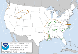
As mentioned a couple of days ago, a potential severe weather event is on it's way later in the afternoon into the early evening tomorrow. (Latest maps and discussion from the SPC are below) The Storm Prediction Center has now upgraded to a 30% risk area anywhere west of I65. Storms will develop by late afternoon in Southern Illinois and Western Kentucky, then approach Kentuckiana by early evening. These storms will rapidly become severe with the main threat being large hail. In fact, the potential for very large hail is increasing with the strong cooling aloft. I would not be suprised to see some hail as big as golf balls with some of the storms that form. A secondary, but rather small threat, will be isolated tornadoes. We may see portions of the 30% risk area upgraded to a moderate risk due to the potential for very large hail.
DAY 2 SEVERE WEATHER OUTLOOK-Monday

DAY 2 SEVERE WEATHER PROBABILITY OUTLOOK-Monday

SPC SAYS: WHILE BOUNDARY LAYER WILL BE COMPARABLY DRIER TO THAT ALONG THE CNTRL/ERN GULF COAST...DEWPOINTS IN THE LOWER/MID 50S COUPLED WITH STRONG COOLING ALOFT /I.E. 500 MB TEMPERATURES DECREASING TO -18 TO -20 C/ WILL RESULT IN AIR MASS DESTABILIZATION AHEAD OF COLD FRONT MONDAY GIVEN SUFFICIENT DAYTIME HEATING. FORECAST SOUNDINGS INDICATE CONSIDERABLE STEEPENING TO LOW/MID-TROPOSPHERIC LAPSE RATES...LARGELY CONTRIBUTING TO MLCAPE OF 1000-1500 J/KG DURING THE PEAK OF THE DIURNAL HEATING CYCLE. THIS AIR MASS DESTABILIZATION IN CONCERT WITH A ZONE OF DEEP ASCENT AHEAD OF UPPER SYSTEM SHOULD FOSTER SCATTERED TSTMS BY AFTERNOON ALONG COLD FRONT FROM NERN AR/SERN MO EVENTUALLY INTO SRN PARTS OF IL/IND/WRN TN AND PERHAPS NRN MS. 45-55 KT OF DEEP-LAYER SHEAR WILL REMAIN QUITE SUPPORTIVE OF SUPERCELLS WITH LARGE HAIL BEING THE PRIMARY SEVERE WEATHER THREAT. ISOLATED TORNADOES AND LOCALLY DAMAGING WIND GUSTS WILL ALSO POSSIBLE WITH ANY STRONGER/SUSTAINED SUPERCELLS THAT DEVELOP.
I will try and update as much as I can throughout the day. If I don't on here, I will be doing continous updates on TWITTER...everyone have a God blessed night!
Saturday, April 11, 2009
Saturday/Late Morning
Follow my TWITTER weather updates and add me on FACEBOOK by referring to the right side of your screen. If you have any weather questions, drop me a comment here or email me at pateo90@hotmail.com
WEATHER CODE: GREEN ***No hazardous weather expected***


WEATHER CODE: GREEN ***No hazardous weather expected***

We are getting a much needed break weatherwise after showers and thunderstorms moved through the region yesterday. Temperatures today will rise into the upper 50's and lower 60's region wide with sunny skies. We are looking at a GREAT Easter, with temperatures in the lower and middle 60's and again sunny skies!
Enjoy though, because showers and thunderstorms will return Monday. The Storm Prediction Center has highlighted the entire region in a SLIGHT RISK for severe weather. (Latest maps and discussion from Storm Prediction Center below) Several ingredients are present in the latest forecast soundings. This includes a pretty decent set-up for supercelluar thunderstorms capable of producing large hail and tornadoes. Instability is still in question, however the latest soundings have began to increase the moisture influx across the region. The SPC has the area in a 15% risk area, however I believe this will be bumped up to at least a 30% risk area by tomorrow. All in all, we will have to keep an eye on things Monday, as even more severe weather will threaten the region.
DAY 3 SEVERE WEATHER OUTLOOK-Monday

DAY 3 SEVERE WEATHER PROBABILITY OUTLOOK-Monday

SPC SAYS: FARTHER NORTH...IN THE WAKE OF EARLY MORNING MCS IT APPEARS A NARROW AXIS OF MOISTURE WILL SURGE NORTH AHEAD OF COLD FRONT/SFC LOW INTO THE LOWER OH VALLEY REGION FROM SRN IL INTO SRN IND. MODELS INSIST THAT BOUNDARY LAYER HEATING WILL BE MAXIMIZED FROM NERN LA/WRN MS INTO SRN IL WHICH SHOULD RESULT IN MORE THAN ADEQUATE INSTABILITY FOR CONVECTIVE DEVELOPMENT BY EARLY AFTERNOON...ESPECIALLY IF MID-UPPER 50S DEW POINTS CAN UNDERCUT H5 TEMPERATURES NEAR -20C. SEVERE THUNDERSTORMS...POSSIBLY SUPERCELLULAR IN NATURE...WILL LIKELY EVOLVE IN THE HEAT OF THE DAY ALONG ADVANCING COLD FRONT FROM WRN MS INTO SRN IL BEFORE SPREADING ACROSS THE NRN GULF STATES/TN VALLEY/LOWER OH VALLEY REGION AND WEAKENING LATE IN THE EVENING.
Friday, April 10, 2009
Friday/Late Evening
Severe weather continues across the southeast, and it shows no signs of letting up. For a list of storm reports SO FAR click HERE
On the right side of your screen you will see my TWITTER weather updates. You will also see a new FACEBOOK badge. Add me on FACEBOOK by clicking on the picture...
If you want to ask me a weather question, either drop me a comment or email me at pateo90@hotmail.com
Everyone have a safe and God blessed night!
Friday/Early Evening
WEATHER CODE: YELLOW ***Showers will continue for a majority of the evening hours***


Don't forget to follow my TWITTER weather updates on the right side of your screen. I am also going to start answering any questions or comments you leave me. If you want to email me...you can do so with this email address... pateo90@hotmail.com

It has been a struggle the last several days to update my weather blog. It may have been my computer or the BLOGGER site itself. If anyone else has a website through blogger...let me know if you have had any problems. It is now working properly, and hopefully will continue to do so.
It has been a very dangerous day just to our south with an ongoing severe weather outbreak, including large tornadoes. The town of Murfreesboro, Tennesee has been hit very hard to what was believed to be multiple tornado touchdowns or tornadoes. 2 deaths have been reported including a mother and here 9 month old baby girl. Please pray for this family and families throughout the ravaged areas.
Their have been several other areas with damage as well with tornado touchdowns across E. Kentucky, Tennesee, and now Northern Georgia is the target area, including Atlanta. This same system did spawn a tornado watch for our area earlier, and their were several reports of funnels and brief tornado touchdowns north of Bowling Green and near Lexington.
On a lighter note, a FREEZE WATCH has been issued for Central Indiana beginning late Saturday night and continuing through Easter morning on Sunday. This includes Jackson, Jennings, and Lawerence.
From the NWS in Indianapolis: TEMERATURES WILL BOTTOM OUT IN THE UPPER 20S TO THE LOWER 30S ACROSS CENTRAL INDIANA JUST BEFORE DAYBREAK.
Easter looks great with sunny skies and highs in the lower and middle 60's. Remember easter is not about easter eggs and bunnies, but about the Man who died on the cross for our sins (Jesus).
On Monday another potent weather system will make its way toward Kentuckiana. The Storm Prediction Center has placed a majority of the area in the 4-8 day severe weather outlook. This usually means a severe weather outbreak is looking likely. The dynamics look great, but as usual, instability may be a limiting factor. Still, this is something to keep an eye on the next few days...stay tuned!

Don't forget to follow my TWITTER weather updates on the right side of your screen. I am also going to start answering any questions or comments you leave me. If you want to email me...you can do so with this email address... pateo90@hotmail.com
Friday/TESTING
TESTING, TESTING, TESTING
I have had technical difficulties with updating the last several days...
I have had technical difficulties with updating the last several days...
Sunday, April 5, 2009
Sunday: 4-5/Early Afternoon 2
A new TORNADO WATCH has been issued for the enire Kentuckiana region. The latest outlining and discussion from the Storm Prediction Center is below...

Storms are beginning to fire in Central Illinois and Western Indiana. Any cell that develops out ahead of the line will have the potential to produce tornadoes...
Here is the latest from the SPC: TORNADOES...HAIL TO 2 INCHES IN DIAMETER...THUNDERSTORM WIND GUSTS TO 80 MPH...AND DANGEROUS LIGHTNING ARE POSSIBLE IN THESE AREAS.
DISCUSSION...STRONG S/WV TROUGH AND ASSOCIATED 100KT MID LEVEL JET MAX WILL BE TRACKING INTO LOWER OH VALLEY THIS AFTERNOON. DEEPENING SURFACE LOW MOVES ACROSS CENTRAL IL INTO IND WITH COLD FRONT EXTENDING SSWWD INTO CENTRAL AR ATTM. LOW LEVEL MOISTURE INCREASING IN WARM SECTOR ALONG WITH SURFACE HEATING WILL RAISE MLCAPES TO NEAR 1000 J/KG. SEVERE THUNDERSTORMS INCLUDING SUPERCELLS WILL DEVELOP AHEAD OF SURFACE LOW AND COLD FRONT AND TRACK RAPIDLY ENEWD ACROSS THE WATCH. IN ADDITION TO DAMAGING WINDS/HAIL...TORNADOES WILL BE POSSIBLE...PARTICULARLY WITH ANY SUPERCELL THAT IS ABLE TO DEVELOP IN WARM SECTOR.
Sunday: 4-5/Early Afternoon
WEATHER CODE: RED ***Severe thunderstorms will develop by mid to late afternoon***
Don't have my weather stop light right now...posting from another computer.
The potential has increased significantly for a regional severe weather outbreak across Kentuckiana, and a good majority of the Ohio Valley.
The latest maps from the Storm Predicton Center are below. Storms will develop by about 3 o'clock, and storms should be moving out by early evening. Please be mindful of the situation and excercise your severe weather safety plans. I will be updating TWITTER for a majority of the afternoon and you can see those updates on the right side of your screen.
NEW TORNADO WATCH JUST ISSUED...I'll have maps of the outlined counties included shortly...
Saturday, April 4, 2009
Saturday: 4-4/Early Evening
I now have a new feature on my weather blog. On the right side of your screen you will see my TWITTER weather udpdates. To follow me on TWITTER...hit the follow me on twitter link...
Hope you like the new feature...
Hope you like the new feature...
Saturday: 4-4/Mid Afternoon
Here are the latest AFD's (Area Forecast Discussions) from the National Weather Services in Louisville, Central Illinois, Northern Indiana, Paducah, and Wilmington
Concerning severe weather potential tomorrow afternoon/evening...
NWS in Louisville: SUNDAY/SUNDAY NIGHT WILL BE THE MAIN SHORT TERM FOCUS. A LOW PRESSURE SYSTEM SITTING OVER THE PLAINS THIS AFTERNOON WILL MAKE IT/S WAY EAST TO CENTRAL IL BY EARLY AFTERNOON SUNDAY. THIS SYSTEM IS EXPECTED TO SPAWN A QUASI LINEAR LINE OF CONVECTION WITH CELLULAR STRUCTURES ALONG IT/S COLD FRONT. ALTHOUGH STORMS MAY START OUT ELEVATED OVER IA/IL SUN MORNING...THEY WILL BECOME MORE SURFACE BASED AS THEY MOVE EAST INTO KY/IN BY SUNDAY AFTERNOON. AS MENTIONED PREVIOUSLY...FORECAST SOUNDINGS INDICATE STRONG WIND FIELDS AND LONG THIN CAPE BETWEEN 500-1000 J/KG IN SUPPORT OF DAMAGING WINDS AND HAIL BEING THE PRIMARY THREATS. HOWEVER...A TORNADO OR TWO MAY ALSO BE POSSIBLE GIVEN THE STRONG WIND FIELDS AND SUPERCELLULAR STRUCTURE ANTICIPATED. PRIME TIME FOR ANY SEVERE WEATHER OVER OUR FORECAST AREA (FA) WILL BE FROM 21Z SUN TO 5Z MON.
NWS in Central Illinois: SPC DAY 2 OUTLOOK HAS OUR SE CWA IN A SLIGHT RISK FOR SUNDAY...WITH HAIL AND WIND THE PRIMARY HAZARDS. ENOUGH ROTATIONAL SHEAR WILL BE PRESENT IN THE MID LEVELS FOR SOME ROTATING SUPERCELLS...SO ISOLATED TORNADOES WILL BE POSSIBLE...BUT MAINLY SOUTH OF OUR AREA...FARTHER SOUTH ALONG THE COLD FRONT.
NWS in Northern Indiana: LATE SUNDAY MORNING/SUNDAY AFTERNOON...BOTH THE GFS/NAM ADVERTISE THAT A CONNECTION TO THE GULF GETS ESTABLISHED...WITH 1 INCH PWATS RACING NORTHEAST INTO SOUTHERN INDIANA BY 18Z AHEAD OF THE UPPERWAVE. THIS ADDED MOISTURE...ALONG WITH SLIGHT STRENGTHENING OF THE SURFACE/H850 LOW WILL HELP SPAWN A BLOSSOMING AREA OF CONVECTION OVER SOUTHERN INDIANA IN THE AFTERNOON WHERE SURFACE BASED INSTABILITY WILL BE REALIZED. FURTHER NORTH...IN OUR AREA..AS THIS MOISTURE LIFTS OVER THE COLD DOME AT THE SURFACE...EXPECT PRECIPRATES TO RAPIDLY STRENGTHEN AND ALTHOUGH THERE WILL BE LITTLE/NO SURFACE BASED INSTABILITY...THERE LOOKS TO BE AMPLE ELEVATED INSTABILITY WITH THUNDER A GOOD BET GIVEN SHOWALTERS AROUND -2 TO-4C AND ELEVATED CAPES OF 100-300 J/KG OVER MY SOUTHERN ZONES. WITH THIS AMOUNT OF ELEVATED INSTABILITY...CERTAINLY CAN/T RULE OUT SOME SMALL HAIL...PARTICULARLY OVER SOUTHERN AREAS ALTHOUGH SEVERE THREAT LOOKS MINIMAL.
NWS in Paducah: THE FOCUSED LIFT/INSTABILITY WILL BECOME MAXIMIZED THROUGH THE ENTIRE LAYER DURING THE LATE MORNING AND EARLY AFTERNOON HOURS ON SUNDAY. THE MOST LIKELY INITIATION ZONE FOR ORGANIZED LINEAR CONVECTION WITH SEVERE POTENTIAL WILL LIKELY START ALONG AND EAST OF INTERSTATE 57...SOUTHWEST TO BETWEEN INTERSTATE 55 IN SERN MO AND THE MISSISSIPPI RIVER AFTER 16Z /11 AM CDT/. THERE IS SOME QUESTION AS TO WHETHER 60+ DEWPOINTS WILL MAKE IT INTO THE PENNYRILE REGION OF WEST KENTUCKY BY AFTERNOON...BUT MODEST DEWPOINT VALUES IN THE MID 50S WILL NOT BE OUT OF THE QUESTION.THIS SHOULD BE ENOUGH FOR AT LEAST SOME SEVERE STORMS WITH DAMAGING WINDS AND HAIL ALONG AND EAST OF THE LAND BETWEEN THE LAKES...GIVEN THE 40-50 BULK SHEAR VALUES THROUGH THE 0-6KM LAYER. THE GFS SUGGEST THE MOST UNSTABLE CAPE OVER THE PENNYRILE REGION IN THE 1000-1500 J/KG AT 18Z SUNDAY. THE SHEAR WILL BE THE KEY FOR PINPOINTING THE POTENTIAL FOR SOME ORGANIZED SUPERCELLS. GIVEN THE INFLUX OF DRY AIR INITIALLY BEHIND THIS SYSTEM...TIMING WILL CRITICAL FOR SEVERE POTENTIAL DURING THE AFTERNOON.
NWS in Wilmington: AN EMBEDDED UPPER SHORTWAVE WILL ACQUIRE A NEGATIVE TILT AS IT ROTATES AROUND THE DIGGING MEAN TROUGH TOMORROW NIGHT. THIS WILL ACT TO CONTINUE TO DEEPEN THE SURFACE LOW TOMORROW EVENING AS IT TRACKS INTO CENTRAL OHIO. THE RESULTING LOW LEVEL WIND SHEAR WILL BE STRONG...AND MAY SET THE STATE FOR STRONG OR SEVERE THUNDERSTORMS TOMORROW EVENING ACROSS THE SOUTHERN HALF OF THE CWA AS A COLD FRONT APPROACHES. THE SEVERE THREAT WILL BE HIGHLY CONDITIONAL ON BOUNDARY LAYER INSTABILITY...WHICH BOTH NAM AND GFS ARE FORECASTING TO BE ADEQUATE FOR AT LEAST A FEW SEVERE STORMS. WILL GET A BETTER HANDLE ON THE SEVERE THREAT TOMORROW AS THE LOW LEVEL MOISTURE FIELD BECOMES BETTER DEFINED. NEED TO LOOK AS FAR AS EAST TX BEFORE YOU FIND DEWPOINTS IN THE MID 50S...SO NOT SURE THAT MOISTURE WILL HAVE TIME TO MAKE IT THIS FAR. LACK OF LOW-LEVEL CAPE WILL KEEP THE SEVERE THREAT CONFINED PRIMARILY TO STRONG WINDS AND MARGINALLY SEVERE HAIL...DESPITE ADEQUATE SHEAR FOR SUPERCELLS. STRENGTHENING LOW LEVEL JET AND ASSOCIATED DEEP FRONTOGENESIS WILL ENHANCE PRECIP RATES NEAR AND JUST NORTH OF THE WARM FRONT...SO WILL NEED TO WATCH THE NORTHERN CWA FOR A HEAVY RAIN THREAT SUNDAY NIGHT.
Saturday: 4-4/Early Afternoon
WEATHER CODE: GREEN ***No hazardous weather expected***


Sorry for no posts lately. I decided to take a break from my computer and cell phone. They become distractions in my relationship with God, and He's the only one who matters in the end.
It has been a beautiful day outside with clear blue skies and temperatures in the middle 60's across the entire Kentuckiana region. You better enjoy it though, because showers and storms return tomorrow, and we may be talking some severe weather.
The Storm Prediction Center has placed the entire region in a SLIGHT RISK for severe weather. (Maps, and latest SPC discussion are below) Several important factors are coming together for at least a regional outbreak of severe weather across Southern/Central Indiana, Kentucky, and Southwest Ohio. Impressive wind fields, changing with height in the upper atmosphere, MUCAPE of 500-1000 j/kg, and LI's (lifted indices) from -3 to -5 will all contribute to our severe weather threat tomorrow afternoon. Damaging winds, large hail, and even isolated tornadoes will be a possibility as these storms develop. The threat should wane as storms move east toward E. Kentucky, and Central/Eastern Ohio during the night time hours. The SPC only has our region in a 15% risk area, however I expect wind/hail probabilities to be 30% with the DAY 1 outlook scheduled for very early tomorrow morning.
SPC says: WITH FAIRLY STRONG WIND FIELDS -- INCREASING AND VEERING WITH HEIGHT -- FORECAST ATOP THE WARM SECTOR...SHEAR WILL SUPPORT ORGANIZED/SUPERCELL STORMS. WHILE A TORNADO OR TWO WILL BE POSSIBLE...HAIL AND DAMAGING WINDS SHOULD BE THE PRIMARY SEVERE THREATS -- PARTICULARLY WITH A QUASI-LINEAR STORM MODE ANTICIPATED. THREAT SHOULD DIMINISH SLOWLY THROUGH THE EVENING...WITH THE ONSET OF COOLING/STABILIZATION.
SEVERE WEATHER OUTLOOK-Sunday

SEVERE WEATHER PROBABILITY-Sunday

Subscribe to:
Posts (Atom)
.jpg)