WEATHER CODE: GREEN for tonight-***No hazardous weather expected***
YELLOW for tomorrow-***Severe thunderstorms possible***
Two weather lights for tonight due to the potential for severe weather tomorrow. I wanted to get the word out as soon as possible. As meteorologists and weather forecasters, our job is to keep you safe and ahead of the storm.
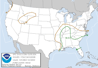
As mentioned a couple of days ago, a potential severe weather event is on it's way later in the afternoon into the early evening tomorrow. (Latest maps and discussion from the SPC are below) The Storm Prediction Center has now upgraded to a 30% risk area anywhere west of I65. Storms will develop by late afternoon in Southern Illinois and Western Kentucky, then approach Kentuckiana by early evening. These storms will rapidly become severe with the main threat being large hail. In fact, the potential for very large hail is increasing with the strong cooling aloft. I would not be suprised to see some hail as big as golf balls with some of the storms that form. A secondary, but rather small threat, will be isolated tornadoes. We may see portions of the 30% risk area upgraded to a moderate risk due to the potential for very large hail.
DAY 2 SEVERE WEATHER OUTLOOK-Monday
DAY 2 SEVERE WEATHER PROBABILITY OUTLOOK-Monday
SPC SAYS: WHILE BOUNDARY LAYER WILL BE COMPARABLY DRIER TO THAT ALONG THE CNTRL/ERN GULF COAST...DEWPOINTS IN THE LOWER/MID 50S COUPLED WITH STRONG COOLING ALOFT /I.E. 500 MB TEMPERATURES DECREASING TO -18 TO -20 C/ WILL RESULT IN AIR MASS DESTABILIZATION AHEAD OF COLD FRONT MONDAY GIVEN SUFFICIENT DAYTIME HEATING. FORECAST SOUNDINGS INDICATE CONSIDERABLE STEEPENING TO LOW/MID-TROPOSPHERIC LAPSE RATES...LARGELY CONTRIBUTING TO MLCAPE OF 1000-1500 J/KG DURING THE PEAK OF THE DIURNAL HEATING CYCLE. THIS AIR MASS DESTABILIZATION IN CONCERT WITH A ZONE OF DEEP ASCENT AHEAD OF UPPER SYSTEM SHOULD FOSTER SCATTERED TSTMS BY AFTERNOON ALONG COLD FRONT FROM NERN AR/SERN MO EVENTUALLY INTO SRN PARTS OF IL/IND/WRN TN AND PERHAPS NRN MS. 45-55 KT OF DEEP-LAYER SHEAR WILL REMAIN QUITE SUPPORTIVE OF SUPERCELLS WITH LARGE HAIL BEING THE PRIMARY SEVERE WEATHER THREAT. ISOLATED TORNADOES AND LOCALLY DAMAGING WIND GUSTS WILL ALSO POSSIBLE WITH ANY STRONGER/SUSTAINED SUPERCELLS THAT DEVELOP.
I will try and update as much as I can throughout the day. If I don't on here, I will be doing continous updates on TWITTER...everyone have a God blessed night!


.jpg)
No comments:
Post a Comment